

Echternach-Diekirch-Colmar Berg
A cycling route starting in Luxembourg, District de Luxembourg, Luxembourg.
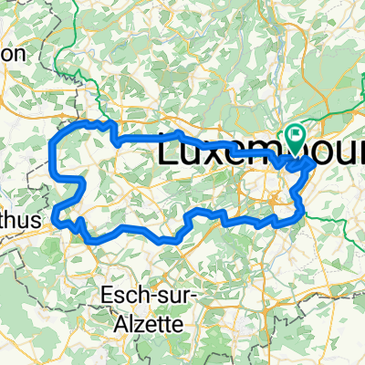
Overview
About this route
- -:--
- Duration
- 114.1 km
- Distance
- 443 m
- Ascent
- 433 m
- Descent
- ---
- Avg. speed
- ---
- Max. altitude
Route quality
Waytypes & surfaces along the route
Waytypes
Cycleway
54.8 km
(48 %)
Quiet road
17.1 km
(15 %)
Surfaces
Paved
111.8 km
(98 %)
Asphalt
107.3 km
(94 %)
Concrete
3.4 km
(3 %)
Continue with Bikemap
Use, edit, or download this cycling route
You would like to ride Echternach-Diekirch-Colmar Berg or customize it for your own trip? Here is what you can do with this Bikemap route:
Free features
- Save this route as favorite or in collections
- Copy & plan your own version of this route
- Split it into stages to create a multi-day tour
- Sync your route with Garmin or Wahoo
Premium features
Free trial for 3 days, or one-time payment. More about Bikemap Premium.
- Navigate this route on iOS & Android
- Export a GPX / KML file of this route
- Create your custom printout (try it for free)
- Download this route for offline navigation
Discover more Premium features.
Get Bikemap PremiumFrom our community
Other popular routes starting in Luxembourg
 Route 10/05/25
- Distance
- 50.4 km
- Ascent
- 729 m
- Descent
- 751 m
- Location
- Luxembourg, District de Luxembourg, Luxembourg
 Playing in the Woods 13 December 08:00
- Distance
- 28.9 km
- Ascent
- 321 m
- Descent
- 324 m
- Location
- Luxembourg, District de Luxembourg, Luxembourg
 J1A RC2 MIP2018
- Distance
- 50.2 km
- Ascent
- 119 m
- Descent
- 226 m
- Location
- Luxembourg, District de Luxembourg, Luxembourg
 9 Mai Tour
- Distance
- 72.5 km
- Ascent
- 837 m
- Descent
- 835 m
- Location
- Luxembourg, District de Luxembourg, Luxembourg
 MOSELSKOU CYKLOSTEZKOU VÍNA (HOTEL)
- Distance
- 336.8 km
- Ascent
- 1,311 m
- Descent
- 1,534 m
- Location
- Luxembourg, District de Luxembourg, Luxembourg
 VTT City to Kopstal
- Distance
- 41.4 km
- Ascent
- 849 m
- Descent
- 849 m
- Location
- Luxembourg, District de Luxembourg, Luxembourg
 PC02 d'Echternach
- Distance
- 49.1 km
- Ascent
- 395 m
- Descent
- 550 m
- Location
- Luxembourg, District de Luxembourg, Luxembourg
 LUXEMBURG-LUXEMBUG
- Distance
- 66.2 km
- Ascent
- 523 m
- Descent
- 521 m
- Location
- Luxembourg, District de Luxembourg, Luxembourg
Open it in the app