

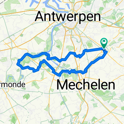
Lichtaart NO
A cycling route starting in Lier, Flemish Region, Belgium.
Overview
About this route
Dag tocht met verschillende mogelijkheden onderweg om de dorstigen te laven !
Schol
- 5 h 14 min
- Duration
- 89.3 km
- Distance
- 196 m
- Ascent
- 200 m
- Descent
- 17.1 km/h
- Avg. speed
- 34 m
- Max. altitude

Route quality
Waytypes & surfaces along the route
Waytypes
Quiet road
47.3 km
(53 %)
Cycleway
14.3 km
(16 %)
Surfaces
Paved
42.9 km
(48 %)
Unpaved
7.1 km
(8 %)
Asphalt
28.6 km
(32 %)
Concrete
8 km
(9 %)
Route highlights
Points of interest along the route
Point of interest after 10.5 km
cafe "De Kruik"
Point of interest after 12 km
Cafe "De Kroon"
Point of interest after 21.4 km
cafe "De Toekomst"
Point of interest after 35.6 km
cafe "De Leeuw"
Point of interest after 40.9 km
cafe "De Heide"
Point of interest after 41.2 km
cafe "De Nete"
Point of interest after 62 km
Cafe "Berkemus"
Point of interest after 62.1 km
cafe "De Snelle Duif"
Point of interest after 65.3 km
cafe " Centrum "
Continue with Bikemap
Use, edit, or download this cycling route
You would like to ride Lichtaart NO or customize it for your own trip? Here is what you can do with this Bikemap route:
Free features
- Save this route as favorite or in collections
- Copy & plan your own version of this route
- Split it into stages to create a multi-day tour
- Sync your route with Garmin or Wahoo
Premium features
Free trial for 3 days, or one-time payment. More about Bikemap Premium.
- Navigate this route on iOS & Android
- Export a GPX / KML file of this route
- Create your custom printout (try it for free)
- Download this route for offline navigation
Discover more Premium features.
Get Bikemap PremiumFrom our community
Other popular routes starting in Lier
 2024 Lier - Sint Niklaas via Temse
- Distance
- 52.4 km
- Ascent
- 148 m
- Descent
- 137 m
- Location
- Lier, Flemish Region, Belgium
 Lichtaart NO
- Distance
- 89.3 km
- Ascent
- 196 m
- Descent
- 200 m
- Location
- Lier, Flemish Region, Belgium
 beire fluit
- Distance
- 98.2 km
- Ascent
- 56 m
- Descent
- 56 m
- Location
- Lier, Flemish Region, Belgium
 Lier - Eiffel (Deutschland)
- Distance
- 402.6 km
- Ascent
- 1,257 m
- Descent
- 1,257 m
- Location
- Lier, Flemish Region, Belgium
 temse
temse- Distance
- 84.4 km
- Ascent
- 60 m
- Descent
- 60 m
- Location
- Lier, Flemish Region, Belgium
 fiets
fiets- Distance
- 34.9 km
- Ascent
- 30 m
- Descent
- 30 m
- Location
- Lier, Flemish Region, Belgium
 mechelen
- Distance
- 45.1 km
- Ascent
- 56 m
- Descent
- 56 m
- Location
- Lier, Flemish Region, Belgium
 Netevallei-route 2
- Distance
- 68.8 km
- Ascent
- 51 m
- Descent
- 51 m
- Location
- Lier, Flemish Region, Belgium
Open it in the app