

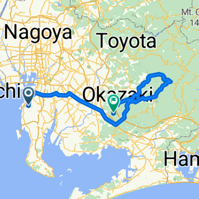
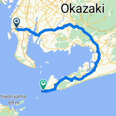
Chita 70.3 Bike course
A cycling route starting in Tokoname, Aichi, Japan.
Overview
About this route
- -:--
- Duration
- 90.1 km
- Distance
- 172 m
- Ascent
- 126 m
- Descent
- ---
- Avg. speed
- ---
- Max. altitude
Route quality
Waytypes & surfaces along the route
Waytypes
Road
62.2 km
(69 %)
Access road
14.4 km
(16 %)
Surfaces
Paved
3.6 km
(4 %)
Paved (undefined)
2.7 km
(3 %)
Asphalt
0.9 km
(1 %)
Undefined
86.5 km
(96 %)
Continue with Bikemap
Use, edit, or download this cycling route
You would like to ride Chita 70.3 Bike course or customize it for your own trip? Here is what you can do with this Bikemap route:
Free features
- Save this route as favorite or in collections
- Copy & plan your own version of this route
- Split it into stages to create a multi-day tour
- Sync your route with Garmin or Wahoo
Premium features
Free trial for 3 days, or one-time payment. More about Bikemap Premium.
- Navigate this route on iOS & Android
- Export a GPX / KML file of this route
- Create your custom printout (try it for free)
- Download this route for offline navigation
Discover more Premium features.
Get Bikemap PremiumFrom our community
Other popular routes starting in Tokoname
 ⑪タコと亀
⑪タコと亀- Distance
- 15.1 km
- Ascent
- 0 m
- Descent
- 0 m
- Location
- Tokoname, Aichi, Japan
 133, Onocho 1-Chōme, Tokoname a 1-2-205, Tsutsujigaoka 2-Chōme, Chita
- Distance
- 9.3 km
- Ascent
- 493 m
- Descent
- 478 m
- Location
- Tokoname, Aichi, Japan
 Japan-trip
- Distance
- 2,255.8 km
- Ascent
- 6,575 m
- Descent
- 6,574 m
- Location
- Tokoname, Aichi, Japan
 9−2, 常滑市 to 岐阜市
- Distance
- 70.6 km
- Ascent
- 622 m
- Descent
- 638 m
- Location
- Tokoname, Aichi, Japan
 csita
csita- Distance
- 132.6 km
- Ascent
- 1,444 m
- Descent
- 1,419 m
- Location
- Tokoname, Aichi, Japan
 nagoya 2013
- Distance
- 763.2 km
- Ascent
- 8,279 m
- Descent
- 8,278 m
- Location
- Tokoname, Aichi, Japan
 Asukadai 6-Chōme, Tokoname to Iragocho Miyashita, Tahara
- Distance
- 126.3 km
- Ascent
- 1,027 m
- Descent
- 1,049 m
- Location
- Tokoname, Aichi, Japan
 Chita 70.3 Bike course
- Distance
- 90.1 km
- Ascent
- 172 m
- Descent
- 126 m
- Location
- Tokoname, Aichi, Japan
Open it in the app