

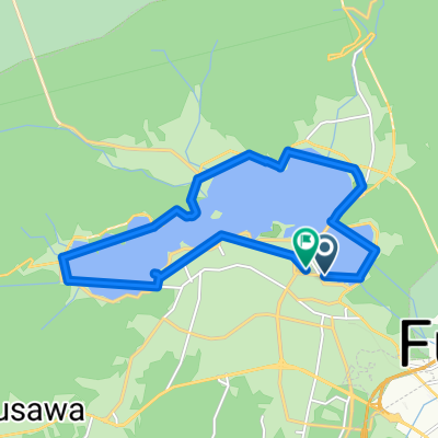
Mt Fuji Subaru line
A cycling route starting in Fujikawaguchiko, Yamanashi, Japan.
Overview
About this route
- -:--
- Duration
- 23.5 km
- Distance
- 1,222 m
- Ascent
- 0 m
- Descent
- ---
- Avg. speed
- ---
- Max. altitude
Route quality
Waytypes & surfaces along the route
Surfaces
Paved
5.2 km
(22 %)
Asphalt
5.2 km
(22 %)
Undefined
18.4 km
(78 %)
Continue with Bikemap
Use, edit, or download this cycling route
You would like to ride Mt Fuji Subaru line or customize it for your own trip? Here is what you can do with this Bikemap route:
Free features
- Save this route as favorite or in collections
- Copy & plan your own version of this route
- Sync your route with Garmin or Wahoo
Premium features
Free trial for 3 days, or one-time payment. More about Bikemap Premium.
- Navigate this route on iOS & Android
- Export a GPX / KML file of this route
- Create your custom printout (try it for free)
- Download this route for offline navigation
Discover more Premium features.
Get Bikemap PremiumFrom our community
Other popular routes starting in Fujikawaguchiko
 富士山 伊豆 熱海 伊東
- Distance
- 100.7 km
- Ascent
- 856 m
- Descent
- 1,696 m
- Location
- Fujikawaguchiko, Yamanashi, Japan
 5 Lakes of Fuji mike
- Distance
- 131.3 km
- Ascent
- 649 m
- Descent
- 1,387 m
- Location
- Fujikawaguchiko, Yamanashi, Japan
 🇯🇵 JPN D12b - YOKOHAMA
- Distance
- 210.2 km
- Ascent
- 489 m
- Descent
- 1,330 m
- Location
- Fujikawaguchiko, Yamanashi, Japan
 Yamanaka Lake to Fuji river
- Distance
- 149.5 km
- Ascent
- 2,518 m
- Descent
- 3,222 m
- Location
- Fujikawaguchiko, Yamanashi, Japan
 Day 10:Kawaguchiko-Izunagaoka
- Distance
- 99.4 km
- Ascent
- 1,936 m
- Descent
- 2,768 m
- Location
- Fujikawaguchiko, Yamanashi, Japan
 kawaguchi and fujikyu
- Distance
- 26 km
- Ascent
- 389 m
- Descent
- 391 m
- Location
- Fujikawaguchiko, Yamanashi, Japan
 6713-3 to 6713-6
- Distance
- 15.1 km
- Ascent
- 20 m
- Descent
- 56 m
- Location
- Fujikawaguchiko, Yamanashi, Japan
 2011-08-11環富士四湖
- Distance
- 64.5 km
- Ascent
- 490 m
- Descent
- 493 m
- Location
- Fujikawaguchiko, Yamanashi, Japan
Open it in the app