

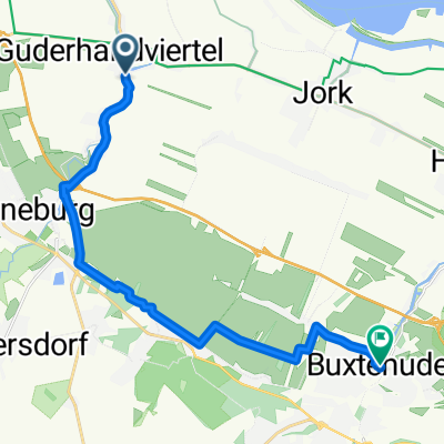
awv52-Stade/Wedel-Niebüll
A cycling route starting in Mittelnkirchen, Lower Saxony, Germany.
Overview
About this route
- -:--
- Duration
- 298.6 km
- Distance
- 114 m
- Ascent
- 114 m
- Descent
- ---
- Avg. speed
- ---
- Max. altitude

Route quality
Waytypes & surfaces along the route
Waytypes
Track
79.7 km
(27 %)
Quiet road
75.8 km
(25 %)
Surfaces
Paved
267.2 km
(89 %)
Unpaved
7 km
(2 %)
Asphalt
225.7 km
(76 %)
Concrete
18.4 km
(6 %)
Continue with Bikemap
Use, edit, or download this cycling route
You would like to ride awv52-Stade/Wedel-Niebüll or customize it for your own trip? Here is what you can do with this Bikemap route:
Free features
- Save this route as favorite or in collections
- Copy & plan your own version of this route
- Split it into stages to create a multi-day tour
- Sync your route with Garmin or Wahoo
Premium features
Free trial for 3 days, or one-time payment. More about Bikemap Premium.
- Navigate this route on iOS & Android
- Export a GPX / KML file of this route
- Create your custom printout (try it for free)
- Download this route for offline navigation
Discover more Premium features.
Get Bikemap PremiumFrom our community
Other popular routes starting in Mittelnkirchen
 Von Neuenkirchen bis Buxtehude
- Distance
- 16.2 km
- Ascent
- 28 m
- Descent
- 24 m
- Location
- Mittelnkirchen, Lower Saxony, Germany
 Neßsand Stade 18
- Distance
- 18.3 km
- Ascent
- 17 m
- Descent
- 0 m
- Location
- Mittelnkirchen, Lower Saxony, Germany
 Altes Land 2.Meile (gelb)
- Distance
- 27.8 km
- Ascent
- 0 m
- Descent
- 0 m
- Location
- Mittelnkirchen, Lower Saxony, Germany
 awv52-Stade/Wedel-Niebüll
- Distance
- 298.6 km
- Ascent
- 114 m
- Descent
- 114 m
- Location
- Mittelnkirchen, Lower Saxony, Germany
 AL - GEEST - ROSENGARTEN
- Distance
- 155.4 km
- Ascent
- 290 m
- Descent
- 290 m
- Location
- Mittelnkirchen, Lower Saxony, Germany
 Von Nessdorf bis Ahrensberg BM-Final
- Distance
- 60 km
- Ascent
- 193 m
- Descent
- 148 m
- Location
- Mittelnkirchen, Lower Saxony, Germany
 Nach Finkw Wedel 53
- Distance
- 53.2 km
- Ascent
- 41 m
- Descent
- 41 m
- Location
- Mittelnkirchen, Lower Saxony, Germany
 Horneburg-Jork-Guthander
- Distance
- 39 km
- Ascent
- 44 m
- Descent
- 42 m
- Location
- Mittelnkirchen, Lower Saxony, Germany
Open it in the app