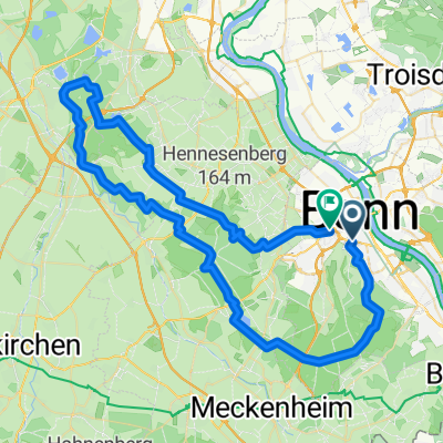
Bonn - Eifel - Westerwald - Bonn
A cycling route starting in Bonn, North Rhine-Westphalia, Germany.
Overview
About this route
Nette Kleine Tour mit tollen Zeltplätzen an den Straßenrändern der Eifel und des Westerwaldes. Besonders der Fockenbach ist sehr zu empfehlen. Die Streckenführung sollte jedoch mit Vorsicht genossen werden, denn die Internetkarten sind nicht das, wass wirklich in der Realität vorliegt. Die Höhenmeter sind aber eine sehr interessante Funktion und geben den Anspruch der Tour vernünftig wieder. Viel Spaß.
- -:--
- Duration
- 189.7 km
- Distance
- 1,343 m
- Ascent
- 1,341 m
- Descent
- ---
- Avg. speed
- ---
- Avg. speed
Continue with Bikemap
Use, edit, or download this cycling route
You would like to ride Bonn - Eifel - Westerwald - Bonn or customize it for your own trip? Here is what you can do with this Bikemap route:
Free features
- Save this route as favorite or in collections
- Copy & plan your own version of this route
- Split it into stages to create a multi-day tour
- Sync your route with Garmin or Wahoo
Premium features
Free trial for 3 days, or one-time payment. More about Bikemap Premium.
- Navigate this route on iOS & Android
- Export a GPX / KML file of this route
- Create your custom printout (try it for free)
- Download this route for offline navigation
Discover more Premium features.
Get Bikemap PremiumFrom our community
Other popular routes starting in Bonn
- Bonn - Ahrquelle - Rursee - Köln
- Distance
- 154 km
- Ascent
- 987 m
- Descent
- 1,006 m
- Location
- Bonn, North Rhine-Westphalia, Germany
- BRT2016-FR: An Rhein und Sieg - RTF des Radsportbezirk Mittelrhein-Süd beim BRT 2016 in Bonn - 105 km Strecke einer Pfeil-Such-Fahrt
- Distance
- 104.9 km
- Ascent
- 1,022 m
- Descent
- 1,023 m
- Location
- Bonn, North Rhine-Westphalia, Germany
- Lockere 1Stunde rund und in Beuel
- Distance
- 21.3 km
- Ascent
- 182 m
- Descent
- 168 m
- Location
- Bonn, North Rhine-Westphalia, Germany
- kleine McDrive-Runde (Ittenbach)
- Distance
- 40.7 km
- Ascent
- 437 m
- Descent
- 437 m
- Location
- Bonn, North Rhine-Westphalia, Germany
- T-Mobile-Rheinauen-Mehlem-Köwi-Dollendorf-Rheinauen-T-Mobile
- Distance
- 15.6 km
- Ascent
- 50 m
- Descent
- 50 m
- Location
- Bonn, North Rhine-Westphalia, Germany
- Ahrtal-Eifel-Kottenforst
- Distance
- 80.9 km
- Ascent
- 925 m
- Descent
- 910 m
- Location
- Bonn, North Rhine-Westphalia, Germany
- BRT2016-FR: An Rhein und Sieg - PSF des Radsportbezirk Mittelrhein-Süd beim BRT 2016 in Bonn - 76 km Strecke
- Distance
- 74.9 km
- Ascent
- 509 m
- Descent
- 509 m
- Location
- Bonn, North Rhine-Westphalia, Germany
- Bonn - Eifel - Westerwald - Bonn
- Distance
- 189.7 km
- Ascent
- 1,343 m
- Descent
- 1,341 m
- Location
- Bonn, North Rhine-Westphalia, Germany
Open it in the app