

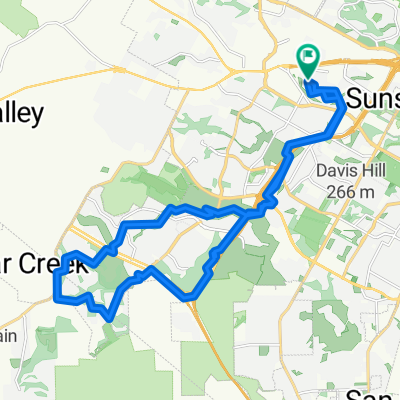
Slow ride in Austin
A cycling route starting in Barton Creek, Texas, United States.
Overview
About this route
- 2 h 42 min
- Duration
- 44 km
- Distance
- 358 m
- Ascent
- 350 m
- Descent
- 16.3 km/h
- Avg. speed
- ---
- Max. altitude
Continue with Bikemap
Use, edit, or download this cycling route
You would like to ride Slow ride in Austin or customize it for your own trip? Here is what you can do with this Bikemap route:
Free features
- Save this route as favorite or in collections
- Copy & plan your own version of this route
- Sync your route with Garmin or Wahoo
Premium features
Free trial for 3 days, or one-time payment. More about Bikemap Premium.
- Navigate this route on iOS & Android
- Export a GPX / KML file of this route
- Create your custom printout (try it for free)
- Download this route for offline navigation
Discover more Premium features.
Get Bikemap PremiumFrom our community
Other popular routes starting in Barton Creek
 5410 Wolf Run, Austin to 5409 Wolf Run, Austin
- Distance
- 35.8 km
- Ascent
- 842 m
- Descent
- 842 m
- Location
- Barton Creek, Texas, United States
 Slow ride in Austin
- Distance
- 44 km
- Ascent
- 358 m
- Descent
- 350 m
- Location
- Barton Creek, Texas, United States
 High-speed route in Austin
- Distance
- 29.1 km
- Ascent
- 245 m
- Descent
- 246 m
- Location
- Barton Creek, Texas, United States
 Home route with Cuernavaca loop
- Distance
- 38.9 km
- Ascent
- 778 m
- Descent
- 791 m
- Location
- Barton Creek, Texas, United States
 Driftwood Loop
- Distance
- 87.5 km
- Ascent
- 449 m
- Descent
- 453 m
- Location
- Barton Creek, Texas, United States
 Barton Hills reversed
- Distance
- 32 km
- Ascent
- 452 m
- Descent
- 456 m
- Location
- Barton Creek, Texas, United States
 Practice? We talking bout practice
- Distance
- 30.7 km
- Ascent
- 401 m
- Descent
- 403 m
- Location
- Barton Creek, Texas, United States
 Austin - William Cannon Dr - Costco - Mopac Cycling Path
- Distance
- 19.7 km
- Ascent
- 93 m
- Descent
- 183 m
- Location
- Barton Creek, Texas, United States
Open it in the app