

0006e Dernbach_Bonefeld_Oberbieber
A cycling route starting in Kaltenengers, Rhineland-Palatinate, Germany.
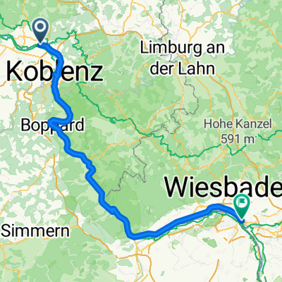
Overview
About this route
Beautiful tour towards Puderbacherland. Mostly well-ridable forest and farm roads.
- -:--
- Duration
- 48.3 km
- Distance
- 881 m
- Ascent
- 882 m
- Descent
- ---
- Avg. speed
- ---
- Max. altitude

Route quality
Waytypes & surfaces along the route
Waytypes
Track
26.1 km
(54 %)
Quiet road
10.6 km
(22 %)
Surfaces
Paved
30.9 km
(64 %)
Unpaved
9.2 km
(19 %)
Asphalt
21.3 km
(44 %)
Paved (undefined)
9.2 km
(19 %)
Route highlights
Points of interest along the route

Point of interest after 4 km
Schöner Blick oberhalb des Neuwieder Zoos über das Neuweider Becken in die Eifel

Point of interest after 7.7 km
Reste eines Römerturms am Limes

Point of interest after 9.6 km
Blick Richtung Pfahlberg und Caan. Im Hintergrund der Köppel.

Point of interest after 21.2 km
Urbacher Weiher

Point of interest after 21.5 km
Blick Richtung Urbach
Continue with Bikemap
Use, edit, or download this cycling route
You would like to ride 0006e Dernbach_Bonefeld_Oberbieber or customize it for your own trip? Here is what you can do with this Bikemap route:
Free features
- Save this route as favorite or in collections
- Copy & plan your own version of this route
- Sync your route with Garmin or Wahoo
Premium features
Free trial for 3 days, or one-time payment. More about Bikemap Premium.
- Navigate this route on iOS & Android
- Export a GPX / KML file of this route
- Create your custom printout (try it for free)
- Download this route for offline navigation
Discover more Premium features.
Get Bikemap PremiumFrom our community
Other popular routes starting in Kaltenengers
 Maifeldtour
- Distance
- 56.7 km
- Ascent
- 525 m
- Descent
- 528 m
- Location
- Kaltenengers, Rhineland-Palatinate, Germany
 Von Engers nach Mainz-Kastel
- Distance
- 111.6 km
- Ascent
- 275 m
- Descent
- 256 m
- Location
- Kaltenengers, Rhineland-Palatinate, Germany
 0006e Dernbach_Bonefeld_Oberbieber
- Distance
- 48.3 km
- Ascent
- 881 m
- Descent
- 882 m
- Location
- Kaltenengers, Rhineland-Palatinate, Germany
 Testroute nach Bingen
- Distance
- 75.2 km
- Ascent
- 290 m
- Descent
- 280 m
- Location
- Kaltenengers, Rhineland-Palatinate, Germany
 Mittelrheintal Koblenz
- Distance
- 55.9 km
- Ascent
- 145 m
- Descent
- 154 m
- Location
- Kaltenengers, Rhineland-Palatinate, Germany
 Engers-Andernach
- Distance
- 14.4 km
- Ascent
- 30 m
- Descent
- 36 m
- Location
- Kaltenengers, Rhineland-Palatinate, Germany
 Test Engers Andernach
- Distance
- 14.5 km
- Ascent
- 35 m
- Descent
- 40 m
- Location
- Kaltenengers, Rhineland-Palatinate, Germany
 2024_07_09_von Neuwied nach Feld
- Distance
- 93.3 km
- Ascent
- 903 m
- Descent
- 764 m
- Location
- Kaltenengers, Rhineland-Palatinate, Germany
Open it in the app