
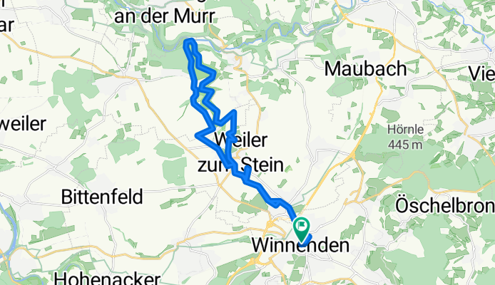
Winnenden, Buchenbachtal, Winnenden
A cycling route starting in Winnenden, Baden-Wurttemberg, Germany.
Overview
About this route
- 1 h 46 min
- Duration
- 22.3 km
- Distance
- 182 m
- Ascent
- 186 m
- Descent
- 12.7 km/h
- Avg. speed
- ---
- Max. altitude

Route photos


Continue with Bikemap
Use, edit, or download this cycling route
You would like to ride Winnenden, Buchenbachtal, Winnenden or customize it for your own trip? Here is what you can do with this Bikemap route:
Free features
- Save this route as favorite or in collections
- Copy & plan your own version of this route
- Sync your route with Garmin or Wahoo
Premium features
Free trial for 3 days, or one-time payment. More about Bikemap Premium.
- Navigate this route on iOS & Android
- Export a GPX / KML file of this route
- Create your custom printout (try it for free)
- Download this route for offline navigation
Discover more Premium features.
Get Bikemap PremiumFrom our community
Other popular routes starting in Winnenden
 Am Jakobsweg 2, Winnenden nach Rosensteinweg 38, Ludwigsburg
- Distance
- 14.4 km
- Ascent
- 123 m
- Descent
- 154 m
- Location
- Winnenden, Baden-Wurttemberg, Germany
 Trekkingroute um Rudersberg
- Distance
- 49.2 km
- Ascent
- 1,028 m
- Descent
- 1,153 m
- Location
- Winnenden, Baden-Wurttemberg, Germany
 Schorndorfer Straße 1, Winnenden nach Bildstraße 6, Winnenden
- Distance
- 22.6 km
- Ascent
- 591 m
- Descent
- 596 m
- Location
- Winnenden, Baden-Wurttemberg, Germany
 171229_P_Winnenden_Korber-Kopf
- Distance
- 19.1 km
- Ascent
- 257 m
- Descent
- 262 m
- Location
- Winnenden, Baden-Wurttemberg, Germany
 winnenden-böblingen
- Distance
- 46.3 km
- Ascent
- 456 m
- Descent
- 319 m
- Location
- Winnenden, Baden-Wurttemberg, Germany
 BUCHNBACH URSPRUNG
- Distance
- 58 km
- Ascent
- 628 m
- Descent
- 621 m
- Location
- Winnenden, Baden-Wurttemberg, Germany
 180708_R_Oppl - Korb - Schorndorf
- Distance
- 32.9 km
- Ascent
- 249 m
- Descent
- 311 m
- Location
- Winnenden, Baden-Wurttemberg, Germany
 Seentour
- Distance
- 67.3 km
- Ascent
- 699 m
- Descent
- 699 m
- Location
- Winnenden, Baden-Wurttemberg, Germany
Open it in the app