

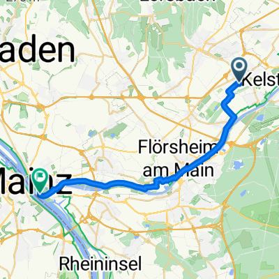
Route nach Mainz
A cycling route starting in Hattersheim, Hesse, Germany.
Overview
About this route
- 1 h 11 min
- Duration
- 20.2 km
- Distance
- 0 m
- Ascent
- 10 m
- Descent
- 17 km/h
- Avg. speed
- ---
- Max. altitude
Route quality
Waytypes & surfaces along the route
Waytypes
Track
10.5 km
(52 %)
Quiet road
5.7 km
(28 %)
Surfaces
Paved
14.4 km
(71 %)
Unpaved
2.6 km
(13 %)
Asphalt
12.5 km
(62 %)
Gravel
2.2 km
(11 %)
Continue with Bikemap
Use, edit, or download this cycling route
You would like to ride Route nach Mainz or customize it for your own trip? Here is what you can do with this Bikemap route:
Free features
- Save this route as favorite or in collections
- Copy & plan your own version of this route
- Sync your route with Garmin or Wahoo
Premium features
Free trial for 3 days, or one-time payment. More about Bikemap Premium.
- Navigate this route on iOS & Android
- Export a GPX / KML file of this route
- Create your custom printout (try it for free)
- Download this route for offline navigation
Discover more Premium features.
Get Bikemap PremiumFrom our community
Other popular routes starting in Hattersheim
 Stauffen II
- Distance
- 25.4 km
- Ascent
- 441 m
- Descent
- 439 m
- Location
- Hattersheim, Hesse, Germany
 Betriebssport-Tour TaunusSparkasse , T2
- Distance
- 60.6 km
- Ascent
- 824 m
- Descent
- 792 m
- Location
- Hattersheim, Hesse, Germany
 Betriebssport-Tour der TaunusSparkasse, T1
- Distance
- 48 km
- Ascent
- 583 m
- Descent
- 562 m
- Location
- Hattersheim, Hesse, Germany
 Giro Hattersheim Tour 3 / 77 km
- Distance
- 71.7 km
- Ascent
- 806 m
- Descent
- 794 m
- Location
- Hattersheim, Hesse, Germany
 RCH-Permanente "Feldberg Tour"
- Distance
- 78.4 km
- Ascent
- 1,210 m
- Descent
- 1,210 m
- Location
- Hattersheim, Hesse, Germany
 Locker Kriftel Höchst Frankfurt
- Distance
- 33.4 km
- Ascent
- 61 m
- Descent
- 77 m
- Location
- Hattersheim, Hesse, Germany
 Route nach Mainz
- Distance
- 20.2 km
- Ascent
- 0 m
- Descent
- 10 m
- Location
- Hattersheim, Hesse, Germany
 Kriftel Marxheim Bahai Lorsbach Runde
- Distance
- 20.7 km
- Ascent
- 348 m
- Descent
- 332 m
- Location
- Hattersheim, Hesse, Germany
Open it in the app