

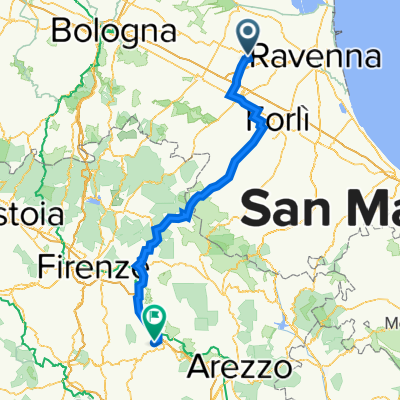
Romagna da Lugo a San Leo
A cycling route starting in Lugo, Emilia-Romagna, Italy.
Overview
About this route
Prevalent plain, Only slope in San Leo
- -:--
- Duration
- 321.6 km
- Distance
- 884 m
- Ascent
- 885 m
- Descent
- ---
- Avg. speed
- ---
- Max. altitude

Route quality
Waytypes & surfaces along the route
Waytypes
Quiet road
131.8 km
(41 %)
Road
96.5 km
(30 %)
Surfaces
Paved
170.4 km
(53 %)
Unpaved
19.3 km
(6 %)
Asphalt
170.4 km
(53 %)
Gravel
16.1 km
(5 %)
Continue with Bikemap
Use, edit, or download this cycling route
You would like to ride Romagna da Lugo a San Leo or customize it for your own trip? Here is what you can do with this Bikemap route:
Free features
- Save this route as favorite or in collections
- Copy & plan your own version of this route
- Split it into stages to create a multi-day tour
- Sync your route with Garmin or Wahoo
Premium features
Free trial for 3 days, or one-time payment. More about Bikemap Premium.
- Navigate this route on iOS & Android
- Export a GPX / KML file of this route
- Create your custom printout (try it for free)
- Download this route for offline navigation
Discover more Premium features.
Get Bikemap PremiumFrom our community
Other popular routes starting in Lugo
 Tappa 2
- Distance
- 152.1 km
- Ascent
- 983 m
- Descent
- 854 m
- Location
- Lugo, Emilia-Romagna, Italy
 5° Orgoglio Pieghevole 2018
- Distance
- 62.8 km
- Ascent
- 39 m
- Descent
- 42 m
- Location
- Lugo, Emilia-Romagna, Italy
 Da Via Padre Massimiliano Maria Kolbe 44, Lugo a Via Padre Massimiliano Maria Kolbe 44, Lugo
- Distance
- 6.9 km
- Ascent
- 5 m
- Descent
- 0 m
- Location
- Lugo, Emilia-Romagna, Italy
 Randonnèe di Romagna_3
- Distance
- 315.1 km
- Ascent
- 5,330 m
- Descent
- 5,297 m
- Location
- Lugo, Emilia-Romagna, Italy
 Bassa Romagna e Alte Marche
- Distance
- 394.7 km
- Ascent
- 3,474 m
- Descent
- 3,475 m
- Location
- Lugo, Emilia-Romagna, Italy
 Lugo Passo Muraglione
- Distance
- 151.1 km
- Ascent
- 1,945 m
- Descent
- 1,798 m
- Location
- Lugo, Emilia-Romagna, Italy
 Bonifica 15 maggio
- Distance
- 21.1 km
- Ascent
- 20 m
- Descent
- 20 m
- Location
- Lugo, Emilia-Romagna, Italy
 Lugo Passo Muraglione Valleverde
- Distance
- 150.8 km
- Ascent
- 1,129 m
- Descent
- 998 m
- Location
- Lugo, Emilia-Romagna, Italy
Open it in the app