

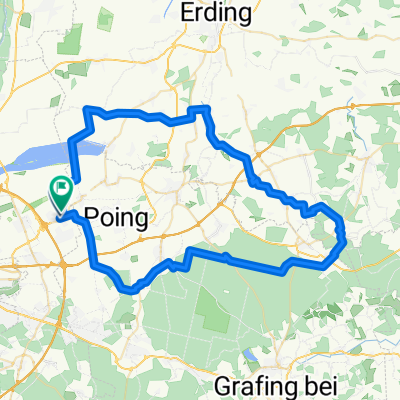
Rundfahrt Landsham - Riem - Anzing - Landsham
A cycling route starting in Kirchheim bei München, Bavaria, Germany.
Overview
About this route
The route is as follows:
Landsham - Kirchheim - Aschheim - Dornach - Alt-Riem - Messestadt Riem - Feldkirchen - Weißenfeld - Parsdorf - Purfing - Frotzhofen - Anzing - Angelbrechting - Poing - Pliening - Landsham.
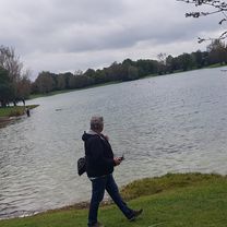
A very beautiful route through town and countryside, over stock and over stone.
Halfway along the route, a visit to the beer garden in Parsdorf is worth it. Fantastic!
- -:--
- Duration
- 39.9 km
- Distance
- 86 m
- Ascent
- 88 m
- Descent
- ---
- Avg. speed
- ---
- Max. altitude
Route quality
Waytypes & surfaces along the route
Waytypes
Path
12.8 km
(32 %)
Road
8.8 km
(22 %)
Surfaces
Paved
30.3 km
(76 %)
Unpaved
5.6 km
(14 %)
Asphalt
28.3 km
(71 %)
Gravel
3.6 km
(9 %)
Continue with Bikemap
Use, edit, or download this cycling route
You would like to ride Rundfahrt Landsham - Riem - Anzing - Landsham or customize it for your own trip? Here is what you can do with this Bikemap route:
Free features
- Save this route as favorite or in collections
- Copy & plan your own version of this route
- Sync your route with Garmin or Wahoo
Premium features
Free trial for 3 days, or one-time payment. More about Bikemap Premium.
- Navigate this route on iOS & Android
- Export a GPX / KML file of this route
- Create your custom printout (try it for free)
- Download this route for offline navigation
Discover more Premium features.
Get Bikemap PremiumFrom our community
Other popular routes starting in Kirchheim bei München
 kirchheim - unterföhring
- Distance
- 24.7 km
- Ascent
- 285 m
- Descent
- 307 m
- Location
- Kirchheim bei München, Bavaria, Germany
 Rund ums Ostkreuz V1
- Distance
- 21.9 km
- Ascent
- 24 m
- Descent
- 23 m
- Location
- Kirchheim bei München, Bavaria, Germany
 Rundfahrt Landsham - Riem - Anzing - Landsham
- Distance
- 39.9 km
- Ascent
- 86 m
- Descent
- 88 m
- Location
- Kirchheim bei München, Bavaria, Germany
 Rund ums Ostkreuz V4
- Distance
- 27.9 km
- Ascent
- 41 m
- Descent
- 42 m
- Location
- Kirchheim bei München, Bavaria, Germany
 Speichersee - Feringasee - Heimstettener See 2
- Distance
- 31.4 km
- Ascent
- 28 m
- Descent
- 25 m
- Location
- Kirchheim bei München, Bavaria, Germany
 HMTB-Isar-Inn-63km
- Distance
- 63.4 km
- Ascent
- 124 m
- Descent
- 123 m
- Location
- Kirchheim bei München, Bavaria, Germany
 Runde West
- Distance
- 67.4 km
- Ascent
- 241 m
- Descent
- 244 m
- Location
- Kirchheim bei München, Bavaria, Germany
 Gut Birkenhof
- Distance
- 18.7 km
- Ascent
- 13 m
- Descent
- 13 m
- Location
- Kirchheim bei München, Bavaria, Germany
Open it in the app