
KIN-22L Spring 2020
2020-04-23 Bike Ride
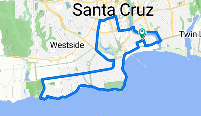
A cycling route starting in Santa Cruz, California, United States.
Overview
About this route
Little bit of a different route.
- -:--
- Duration
- 13.6 km
- Distance
- 38 m
- Ascent
- 39 m
- Descent
- ---
- Avg. speed
- ---
- Max. altitude

Part of
17 stages
Route quality
Waytypes & surfaces along the route
Waytypes
Cycleway
6.4 km
(47 %)
Road
2.3 km
(17 %)
Surfaces
Paved
10.8 km
(80 %)
Asphalt
9.2 km
(68 %)
Paved (undefined)
1.1 km
(8 %)
Route highlights
Points of interest along the route

Photo after 0 km
End of ride.

Photo after 0 km
Starting Point

Photo after 1.3 km
People happy to be surfing again

Photo after 2.5 km
Our rocky shoreline

Photo after 5.2 km
Turning onto Swanton

Photo after 5.7 km
Turning onto Delaware

Photo after 8.3 km
One of my favorite houses along the route.

Photo after 9.4 km
California and Acadia.

Photo after 10.1 km
Prior to starting this biking routine I did not know where this high school was located.

Photo after 10.6 km
Turning off of Walnut onto Center

Photo after 11.5 km
Getting on Riverwalk East.

Photo after 12.3 km
Every time I see people in the river it gives me the willies. I often see teams testing the water but I still shudder to think how dirty it is.

Photo after 13.3 km
They're using the moment to do some construction in there.
Continue with Bikemap
Use, edit, or download this cycling route
You would like to ride 2020-04-23 Bike Ride or customize it for your own trip? Here is what you can do with this Bikemap route:
Free features
- Save this route as favorite or in collections
- Copy & plan your own version of this route
- Sync your route with Garmin or Wahoo
Premium features
Free trial for 3 days, or one-time payment. More about Bikemap Premium.
- Navigate this route on iOS & Android
- Export a GPX / KML file of this route
- Create your custom printout (try it for free)
- Download this route for offline navigation
Discover more Premium features.
Get Bikemap PremiumFrom our community
Other popular routes starting in Santa Cruz
 2020-04-30 New Bike Route - Increasing the distance.
- Distance
- 14.9 km
- Ascent
- 60 m
- Descent
- 61 m
- Location
- Santa Cruz, California, United States
 2020-04-25 Bike Ride
- Distance
- 14.7 km
- Ascent
- 55 m
- Descent
- 57 m
- Location
- Santa Cruz, California, United States
 2020-04-18 Bike Route
- Distance
- 14.8 km
- Ascent
- 53 m
- Descent
- 53 m
- Location
- Santa Cruz, California, United States
 2020-05-16 Bike Ride
- Distance
- 15.4 km
- Ascent
- 43 m
- Descent
- 42 m
- Location
- Santa Cruz, California, United States
 2020-04-15 Bike ride
- Distance
- 14 km
- Ascent
- 55 m
- Descent
- 59 m
- Location
- Santa Cruz, California, United States
 2020-05-21 Bike Ride
- Distance
- 15.4 km
- Ascent
- 41 m
- Descent
- 41 m
- Location
- Santa Cruz, California, United States
 2020-04-23 Bike Ride
- Distance
- 13.6 km
- Ascent
- 38 m
- Descent
- 39 m
- Location
- Santa Cruz, California, United States
 big basin big loop
- Distance
- 105 km
- Ascent
- 1,223 m
- Descent
- 1,222 m
- Location
- Santa Cruz, California, United States
Open it in the app