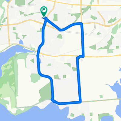
Kingston-Newburgh-Smiths Falls-Kingston.
A cycling route starting in Kingston, Ontario, Canada.
Overview
About this route
Kingston - Lemoine Point Conservation Area. Some easy singletrack in park.
Backroads mostly to Newburgh. Cataraqui Trail at Newburgh. Backtrck to begining of Trail at Strathcona.
Ride entire Cataraqui Trail to Smith's Falls. Trail ends about 300 meters south of Harvey's restaurant.
Retrace Cataraui Trail to Hwy 15. Take backroads to Davis Lock. Carry bike over lock doors at Davis Lock. Short singletrack on south side of Lock leads to gradually bigger gravel roads.
Return to Kingston via Battersea Road and Montreal St.
My travel time: 16 hrs, with three flats. I measured 256 km.
Cataraqui Trail ranges from nice gravel to rather rocky. Not recommended for delicate road tires. Otherwise entire route fine for road bike.
- -:--
- Duration
- 248.5 km
- Distance
- 362 m
- Ascent
- 362 m
- Descent
- ---
- Avg. speed
- ---
- Max. altitude
Continue with Bikemap
Use, edit, or download this cycling route
You would like to ride Kingston-Newburgh-Smiths Falls-Kingston. or customize it for your own trip? Here is what you can do with this Bikemap route:
Free features
- Save this route as favorite or in collections
- Copy & plan your own version of this route
- Split it into stages to create a multi-day tour
- Sync your route with Garmin or Wahoo
Premium features
Free trial for 3 days, or one-time payment. More about Bikemap Premium.
- Navigate this route on iOS & Android
- Export a GPX / KML file of this route
- Create your custom printout (try it for free)
- Download this route for offline navigation
Discover more Premium features.
Get Bikemap PremiumFrom our community
Other popular routes starting in Kingston
- Jen's Birthday Century Ride
- Distance
- 165.9 km
- Ascent
- 332 m
- Descent
- 332 m
- Location
- Kingston, Ontario, Canada
- Kingston Cycling
- Distance
- 54.1 km
- Ascent
- 260 m
- Descent
- 253 m
- Location
- Kingston, Ontario, Canada
- Shorty (15 km)
- Distance
- 14.9 km
- Ascent
- 70 m
- Descent
- 69 m
- Location
- Kingston, Ontario, Canada
- Wolfe Island to Port Metcalfe
- Distance
- 51.8 km
- Ascent
- 99 m
- Descent
- 99 m
- Location
- Kingston, Ontario, Canada
- Wolf Island loop
- Distance
- 44.1 km
- Ascent
- 73 m
- Descent
- 74 m
- Location
- Kingston, Ontario, Canada
- middle road loop
- Distance
- 37.1 km
- Ascent
- 320 m
- Descent
- 327 m
- Location
- Kingston, Ontario, Canada
- Kingston-Ottawa reverse RLCT (182km)
- Distance
- 182 km
- Ascent
- 223 m
- Descent
- 252 m
- Location
- Kingston, Ontario, Canada
- bath road water route
- Distance
- 16.2 km
- Ascent
- 78 m
- Descent
- 100 m
- Location
- Kingston, Ontario, Canada
Open it in the app