

Auf nach Hechlingen
A cycling route starting in Solnhofen, Bavaria, Germany.
Overview
About this route
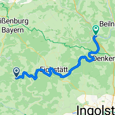
Route from the Hammermühle campsite to Hechlingen. The path follows the Altmühl River to Treuchtlingen.
- -:--
- Duration
- 38.9 km
- Distance
- 377 m
- Ascent
- 305 m
- Descent
- ---
- Avg. speed
- ---
- Max. altitude
Route quality
Waytypes & surfaces along the route
Waytypes
Track
22.6 km
(58 %)
Quiet road
11.3 km
(29 %)
Surfaces
Paved
29.2 km
(75 %)
Unpaved
9.3 km
(24 %)
Asphalt
27.7 km
(71 %)
Gravel
7.4 km
(19 %)
Continue with Bikemap
Use, edit, or download this cycling route
You would like to ride Auf nach Hechlingen or customize it for your own trip? Here is what you can do with this Bikemap route:
Free features
- Save this route as favorite or in collections
- Copy & plan your own version of this route
- Sync your route with Garmin or Wahoo
Premium features
Free trial for 3 days, or one-time payment. More about Bikemap Premium.
- Navigate this route on iOS & Android
- Export a GPX / KML file of this route
- Create your custom printout (try it for free)
- Download this route for offline navigation
Discover more Premium features.
Get Bikemap PremiumFrom our community
Other popular routes starting in Solnhofen
 Von Mörnsheim zum Wettelsheimer Keller
- Distance
- 24 km
- Ascent
- 279 m
- Descent
- 189 m
- Location
- Solnhofen, Bavaria, Germany
 An der Altmühl
- Distance
- 28.3 km
- Ascent
- 175 m
- Descent
- 175 m
- Location
- Solnhofen, Bavaria, Germany
 3. Tag Altmühltal-Radweg
- Distance
- 57 km
- Ascent
- 153 m
- Descent
- 185 m
- Location
- Solnhofen, Bavaria, Germany
 Auf nach Hechlingen
- Distance
- 38.9 km
- Ascent
- 377 m
- Descent
- 305 m
- Location
- Solnhofen, Bavaria, Germany
 Mörnsheim-Solnhofen-Zimmern-Langenaltheim
- Distance
- 28.2 km
- Ascent
- 410 m
- Descent
- 397 m
- Location
- Solnhofen, Bavaria, Germany
 11/06 Mörnsheim - Kipfenberg
- Distance
- 53.6 km
- Ascent
- 195 m
- Descent
- 224 m
- Location
- Solnhofen, Bavaria, Germany
 Gutman
- Distance
- 23.5 km
- Ascent
- 209 m
- Descent
- 222 m
- Location
- Solnhofen, Bavaria, Germany
 Riesradweg 2
- Distance
- 69.1 km
- Ascent
- 426 m
- Descent
- 394 m
- Location
- Solnhofen, Bavaria, Germany
Open it in the app