

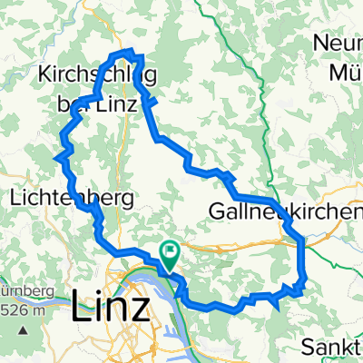
Linz Gründberg - Asberg - GIS (Giselawarte Linz) - Lichtenberg -Diesenleitenweg - Linz Auberg
A cycling route starting in Linz, Upper Austria, Austria.
Overview
About this route
Meine aktuelle Lieblingsroute auf die GIS und zurück.
HINWEIS: die Karte enthält meine individuelle Anfahrt aus Linz St. Margarethen.
Anstieg: Der Anstieg ist gleichmäßig, wenig Straße (abgesehen von der Anfahrt durch die Stadt) und lässt sich gut in einem Fahren. Keine exzessiven Steilpassagen bergauf aber auch keine allzu flachen Stücke.
Downhill: Die Abfahrt durch den Graben und dann über den Diesenleitenweg scheint mir die spannendste Strecke zurück ins Zentrum von Linz zu sein. Sicher keine Problem für geübte Fahrer und solche die sich nicht viel antun.
Vorsichtige Fahrer und Einsteiger könnten mit der Abfahrt überfordert sein, da es einige steilere Wurzelpassagen gibt. Vorsicht auch bei Nässe auf den Wurzeln.
- -:--
- Duration
- 29 km
- Distance
- 654 m
- Ascent
- 654 m
- Descent
- ---
- Avg. speed
- ---
- Avg. speed
Route quality
Waytypes & surfaces along the route
Waytypes
Quiet road
6.7 km
(23 %)
Track
6.7 km
(23 %)
Surfaces
Paved
13.5 km
(46 %)
Unpaved
6.6 km
(23 %)
Asphalt
12.4 km
(43 %)
Ground
3.8 km
(13 %)
Continue with Bikemap
Use, edit, or download this cycling route
You would like to ride Linz Gründberg - Asberg - GIS (Giselawarte Linz) - Lichtenberg -Diesenleitenweg - Linz Auberg or customize it for your own trip? Here is what you can do with this Bikemap route:
Free features
- Save this route as favorite or in collections
- Copy & plan your own version of this route
- Sync your route with Garmin or Wahoo
Premium features
Free trial for 3 days, or one-time payment. More about Bikemap Premium.
- Navigate this route on iOS & Android
- Export a GPX / KML file of this route
- Create your custom printout (try it for free)
- Download this route for offline navigation
Discover more Premium features.
Get Bikemap PremiumFrom our community
Other popular routes starting in Linz
 St. Martin- Lichtenhah-Lichtenberg
- Distance
- 73.2 km
- Ascent
- 1,240 m
- Descent
- 1,241 m
- Location
- Linz, Upper Austria, Austria
 Lichtenberg, Mirellental, Pfenningberg CLONED FROM ROUTE 38001
- Distance
- 54.3 km
- Ascent
- 1,090 m
- Descent
- 1,093 m
- Location
- Linz, Upper Austria, Austria
 Süden von Linz
- Distance
- 42.4 km
- Ascent
- 186 m
- Descent
- 187 m
- Location
- Linz, Upper Austria, Austria
 plesching
- Distance
- 32.6 km
- Ascent
- 325 m
- Descent
- 326 m
- Location
- Linz, Upper Austria, Austria
 4.3.2023
- Distance
- 47.5 km
- Ascent
- 751 m
- Descent
- 749 m
- Location
- Linz, Upper Austria, Austria
 Eine kleine Runde bei Linz
- Distance
- 21.4 km
- Ascent
- 541 m
- Descent
- 444 m
- Location
- Linz, Upper Austria, Austria
 Trail GIS – Bachlberg Variante01
- Distance
- 21.7 km
- Ascent
- 713 m
- Descent
- 850 m
- Location
- Linz, Upper Austria, Austria
 Pfenningberg Tour
- Distance
- 28.9 km
- Ascent
- 458 m
- Descent
- 458 m
- Location
- Linz, Upper Austria, Austria
Open it in the app