

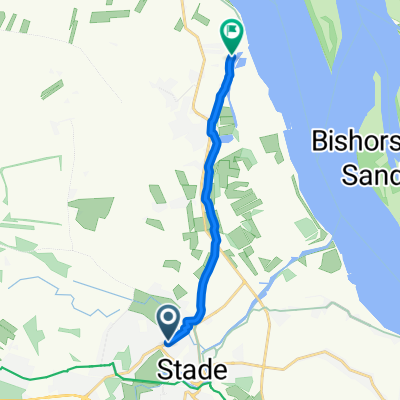
Altländer Straße 13, Stade nach Twielenflether Chaussee 37, Hollern-Twielenfleth
A cycling route starting in Stade, Lower Saxony, Germany.
Overview
About this route
- 42 min
- Duration
- 6.8 km
- Distance
- 21 m
- Ascent
- 20 m
- Descent
- 9.8 km/h
- Avg. speed
- ---
- Max. altitude

Route quality
Waytypes & surfaces along the route
Waytypes
Path
1.2 km
(18 %)
Road
0.9 km
(13 %)
Surfaces
Paved
3.5 km
(51 %)
Asphalt
3.5 km
(51 %)
Undefined
3.4 km
(49 %)
Continue with Bikemap
Use, edit, or download this cycling route
You would like to ride Altländer Straße 13, Stade nach Twielenflether Chaussee 37, Hollern-Twielenfleth or customize it for your own trip? Here is what you can do with this Bikemap route:
Free features
- Save this route as favorite or in collections
- Copy & plan your own version of this route
- Sync your route with Garmin or Wahoo
Premium features
Free trial for 3 days, or one-time payment. More about Bikemap Premium.
- Navigate this route on iOS & Android
- Export a GPX / KML file of this route
- Create your custom printout (try it for free)
- Download this route for offline navigation
Discover more Premium features.
Get Bikemap PremiumFrom our community
Other popular routes starting in Stade
 Elbetour 14.05.2019
- Distance
- 121.2 km
- Ascent
- 166 m
- Descent
- 150 m
- Location
- Stade, Lower Saxony, Germany
 Hansestadt Stade, Stade nach Abbenflether Hafenstraße, Stade
- Distance
- 8.1 km
- Ascent
- 3 m
- Descent
- 7 m
- Location
- Stade, Lower Saxony, Germany
 Krautsand
- Distance
- 46.7 km
- Ascent
- 29 m
- Descent
- 31 m
- Location
- Stade, Lower Saxony, Germany
 Tour zum Gut Kuhla
- Distance
- 34.1 km
- Ascent
- 63 m
- Descent
- 68 m
- Location
- Stade, Lower Saxony, Germany
 Niedersächsische Milchstrasse Radtour 2 (von 3)
- Distance
- 61.2 km
- Ascent
- 59 m
- Descent
- 58 m
- Location
- Stade, Lower Saxony, Germany
 Von Stade zur Hase und Igelroute im Alten Land
- Distance
- 74.4 km
- Ascent
- 158 m
- Descent
- 158 m
- Location
- Stade, Lower Saxony, Germany
 Stade - Hamburg Hbf
- Distance
- 46 km
- Ascent
- 70 m
- Descent
- 62 m
- Location
- Stade, Lower Saxony, Germany
 Stade - Stade Abendrunde
- Distance
- 37.6 km
- Ascent
- 52 m
- Descent
- 52 m
- Location
- Stade, Lower Saxony, Germany
Open it in the app