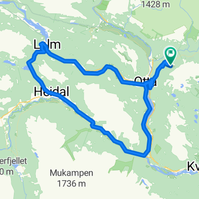
Kvitskriuprestinne
A cycling route starting in Otta, Oppland, Norway.
Overview
About this route
Čím více zde napíšete informací, tím více bude užitečnější pro ostatním uživatele.<br /><br />* Průběh trasy.<br />* Co je zvláštní na této trase?<br />* Proč doporučit tuto trasu?<br />* Co se Vám zde nejvíce líbilo?<br />* Atd.
- -:--
- Duration
- 70.5 km
- Distance
- 1,877 m
- Ascent
- 1,877 m
- Descent
- ---
- Avg. speed
- ---
- Avg. speed
Route quality
Waytypes & surfaces along the route
Waytypes
Busy road
45.8 km
(65 %)
Cycleway
15.7 km
(22 %)
Surfaces
Paved
51.2 km
(73 %)
Unpaved
11 km
(16 %)
Asphalt
51.2 km
(73 %)
Gravel
11 km
(16 %)
Undefined
8.4 km
(12 %)
Route highlights
Points of interest along the route
Point of interest after 34.1 km
Kvitskriuprestinne je skupina vzácných tvarů tzv. zemních pyramid v jihozápadní části pohoří Rondane, u městečka Selsverket , v Norsku . Jedná se o sypké morénové uloženiny dosahující výšky až 8 metrů. Kvitskriuprestinne je chráněný přírodní výtvor. Tyto tzv. zemní pyramidy vytváří sama příroda. Vznikají tím, že voda nebo vítr erodují měkký typ usazených hornin, zatímco tvrdší typ hornin v jejich nadloží erozi úspěšné odolává. Lokalita Kvitskriuprestinne je dosažitelná odbočkou z hlavní silnice E6 v místě vzdáleném asi 3,5 km od města Otta .
Continue with Bikemap
Use, edit, or download this cycling route
You would like to ride Kvitskriuprestinne or customize it for your own trip? Here is what you can do with this Bikemap route:
Free features
- Save this route as favorite or in collections
- Copy & plan your own version of this route
- Sync your route with Garmin or Wahoo
Premium features
Free trial for 3 days, or one-time payment. More about Bikemap Premium.
- Navigate this route on iOS & Android
- Export a GPX / KML file of this route
- Create your custom printout (try it for free)
- Download this route for offline navigation
Discover more Premium features.
Get Bikemap PremiumFrom our community
Other popular routes starting in Otta
- otta oslo aereoporto
- Distance
- 408.9 km
- Ascent
- 1,443 m
- Descent
- 1,670 m
- Location
- Otta, Oppland, Norway
- norge N bm H+T OTTA- Ottadalen-(Lalm) >>Vagamo
- Distance
- 38.1 km
- Ascent
- 404 m
- Descent
- 404 m
- Location
- Otta, Oppland, Norway
- Rondanerittet
- Distance
- 36 km
- Ascent
- 659 m
- Descent
- 657 m
- Location
- Otta, Oppland, Norway
- norge M bm OTTA>>Dovre
- Distance
- 35.2 km
- Ascent
- 476 m
- Descent
- 296 m
- Location
- Otta, Oppland, Norway
- Kvitskriuprestinne
- Distance
- 70.5 km
- Ascent
- 1,877 m
- Descent
- 1,877 m
- Location
- Otta, Oppland, Norway
- Den 9 - expedice Norsko
- Distance
- 127.5 km
- Ascent
- 1,476 m
- Descent
- 2,166 m
- Location
- Otta, Oppland, Norway
- Otta-Lom
- Distance
- 62.4 km
- Ascent
- 681 m
- Descent
- 617 m
- Location
- Otta, Oppland, Norway
- Norway 2014 last
- Distance
- 549.9 km
- Ascent
- 6,028 m
- Descent
- 6,280 m
- Location
- Otta, Oppland, Norway
Open it in the app