

Ride1
A cycling route starting in Honfleur, Normandy, France.
Overview
About this route
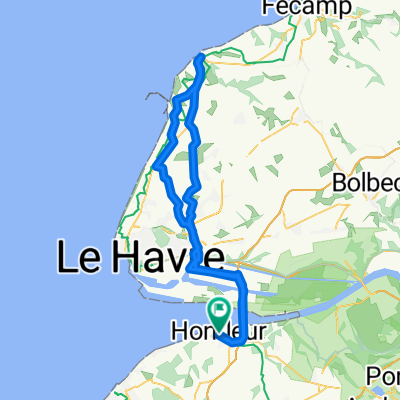
We move from Honfleur where we park the car. Then we cross the Seine with the big Normandie bridge. Then we go up to Etretat!.
And we go back to Honfleur chyau khanako lagi.
It's a 100kms ride.
- -:--
- Duration
- 92.9 km
- Distance
- 362 m
- Ascent
- 362 m
- Descent
- ---
- Avg. speed
- ---
- Max. altitude

Continue with Bikemap
Use, edit, or download this cycling route
You would like to ride Ride1 or customize it for your own trip? Here is what you can do with this Bikemap route:
Free features
- Save this route as favorite or in collections
- Copy & plan your own version of this route
- Split it into stages to create a multi-day tour
- Sync your route with Garmin or Wahoo
Premium features
Free trial for 3 days, or one-time payment. More about Bikemap Premium.
- Navigate this route on iOS & Android
- Export a GPX / KML file of this route
- Create your custom printout (try it for free)
- Download this route for offline navigation
Discover more Premium features.
Get Bikemap PremiumFrom our community
Other popular routes starting in Honfleur
 De Place Jean de Vienne, Honfleur à 27 Quai de Southampton, Le Havre
- Distance
- 27 km
- Ascent
- 3 m
- Descent
- 12 m
- Location
- Honfleur, Normandy, France
 Route in Honfleur
- Distance
- 1.7 km
- Ascent
- 21 m
- Descent
- 21 m
- Location
- Honfleur, Normandy, France
 La Risle
- Distance
- 109.1 km
- Ascent
- 425 m
- Descent
- 424 m
- Location
- Honfleur, Normandy, France
 TDF 2. Etappe Honfleur - Alencon
- Distance
- 181 km
- Ascent
- 1,062 m
- Descent
- 937 m
- Location
- Honfleur, Normandy, France
 honfleur conde sur noireau ep3 CM2017
- Distance
- 108.3 km
- Ascent
- 535 m
- Descent
- 449 m
- Location
- Honfleur, Normandy, France
 Ride1
Ride1- Distance
- 92.9 km
- Ascent
- 362 m
- Descent
- 362 m
- Location
- Honfleur, Normandy, France
 R stage 18..... Le Havre/Honfleur – Bayeux 8 Sept 2012
- Distance
- 92.1 km
- Ascent
- 472 m
- Descent
- 425 m
- Location
- Honfleur, Normandy, France
 Honfleur to Rouen
- Distance
- 85.5 km
- Ascent
- 287 m
- Descent
- 229 m
- Location
- Honfleur, Normandy, France
Open it in the app