

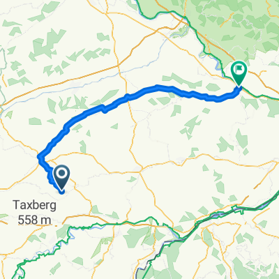
¿ˇ⁄˚? nach ¿ˇ⁄˚?
A cycling route starting in Schönberg, Bavaria, Germany.
Overview
About this route
- 1 h 34 min
- Duration
- 27 km
- Distance
- 110 m
- Ascent
- 150 m
- Descent
- 17.1 km/h
- Avg. speed
- ---
- Max. altitude

Route quality
Waytypes & surfaces along the route
Waytypes
Quiet road
10.2 km
(38 %)
Road
9.2 km
(34 %)
Surfaces
Paved
20.2 km
(75 %)
Unpaved
5.7 km
(21 %)
Asphalt
19.9 km
(74 %)
Gravel
3.8 km
(14 %)
Continue with Bikemap
Use, edit, or download this cycling route
You would like to ride ¿ˇ⁄˚? nach ¿ˇ⁄˚? or customize it for your own trip? Here is what you can do with this Bikemap route:
Free features
- Save this route as favorite or in collections
- Copy & plan your own version of this route
- Sync your route with Garmin or Wahoo
Premium features
Free trial for 3 days, or one-time payment. More about Bikemap Premium.
- Navigate this route on iOS & Android
- Export a GPX / KML file of this route
- Create your custom printout (try it for free)
- Download this route for offline navigation
Discover more Premium features.
Get Bikemap PremiumFrom our community
Other popular routes starting in Schönberg
 Versuch1
- Distance
- 18.3 km
- Ascent
- 144 m
- Descent
- 137 m
- Location
- Schönberg, Bavaria, Germany
 ¿ˇ⁄˚? nach ¿ˇ⁄˚?
- Distance
- 27 km
- Ascent
- 110 m
- Descent
- 150 m
- Location
- Schönberg, Bavaria, Germany
 nördlicher Landkreis Radtour
- Distance
- 38.8 km
- Ascent
- 232 m
- Descent
- 235 m
- Location
- Schönberg, Bavaria, Germany
 Elsass-Bäcker On Tour
- Distance
- 91.6 km
- Ascent
- 373 m
- Descent
- 353 m
- Location
- Schönberg, Bavaria, Germany
 Vilsbiburg - Roßbach + Roßbach - Pfarrkirchen
- Distance
- 95.6 km
- Ascent
- 352 m
- Descent
- 509 m
- Location
- Schönberg, Bavaria, Germany
 Schönberg - Seeon-Seebruck
- Distance
- 56.4 km
- Ascent
- 551 m
- Descent
- 469 m
- Location
- Schönberg, Bavaria, Germany
 Hanging Nord
- Distance
- 13.5 km
- Ascent
- 274 m
- Descent
- 274 m
- Location
- Schönberg, Bavaria, Germany
 Irl 12, Oberbergkirchen nach Irl 12, Oberbergkirchen
- Distance
- 42.1 km
- Ascent
- 633 m
- Descent
- 622 m
- Location
- Schönberg, Bavaria, Germany
Open it in the app