
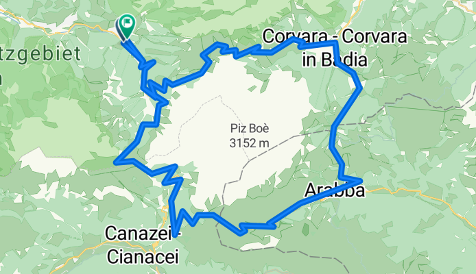
Sella Ronda
A cycling route starting in Sëlva, Trentino-Alto Adige, Italy.
Overview
About this route
Sella Ronda vanaf Selva di Val gardena
- -:--
- Duration
- 60.9 km
- Distance
- 2,250 m
- Ascent
- 1,948 m
- Descent
- ---
- Avg. speed
- 2,247 m
- Max. altitude
Route quality
Waytypes & surfaces along the route
Waytypes
Busy road
55.2 km
(91 %)
Track
2.1 km
(3 %)
Surfaces
Paved
56.9 km
(93 %)
Unpaved
1.4 km
(2 %)
Asphalt
56.7 km
(93 %)
Gravel
0.8 km
(1 %)
Continue with Bikemap
Use, edit, or download this cycling route
You would like to ride Sella Ronda or customize it for your own trip? Here is what you can do with this Bikemap route:
Free features
- Save this route as favorite or in collections
- Copy & plan your own version of this route
- Sync your route with Garmin or Wahoo
Premium features
Free trial for 3 days, or one-time payment. More about Bikemap Premium.
- Navigate this route on iOS & Android
- Export a GPX / KML file of this route
- Create your custom printout (try it for free)
- Download this route for offline navigation
Discover more Premium features.
Get Bikemap PremiumFrom our community
Other popular routes starting in Sëlva
 Sellarunde ab Wolkenstein
- Distance
- 60.7 km
- Ascent
- 2,276 m
- Descent
- 1,952 m
- Location
- Sëlva, Trentino-Alto Adige, Italy
 Sellaronda Bike Tour gegen den Uhrzeigersinn - Rennradtour
- Distance
- 60.3 km
- Ascent
- 2,121 m
- Descent
- 2,120 m
- Location
- Sëlva, Trentino-Alto Adige, Italy
 Selva di Val Gardena (1560 m) - Plan de Gralba (1806 m) - Grödner Joch (2121 m) - Corvara (ca. 1540 m) - Campolongopass (1875 m) - Saviner di Laste (1010 m) - C
- Distance
- 131 km
- Ascent
- 3,733 m
- Descent
- 3,545 m
- Location
- Sëlva, Trentino-Alto Adige, Italy
 8.7. - Langkofelumrundung CLONED FROM ROUTE 249043
- Distance
- 42.6 km
- Ascent
- 1,644 m
- Descent
- 1,642 m
- Location
- Sëlva, Trentino-Alto Adige, Italy
 Sellaronda MTB Track Tour Antiorario
- Distance
- 53.1 km
- Ascent
- 2,928 m
- Descent
- 2,921 m
- Location
- Sëlva, Trentino-Alto Adige, Italy
 Sella Ronda
- Distance
- 57.1 km
- Ascent
- 1,938 m
- Descent
- 1,607 m
- Location
- Sëlva, Trentino-Alto Adige, Italy
 Seiseralm Hüttentour
- Distance
- 44.2 km
- Ascent
- 1,201 m
- Descent
- 1,201 m
- Location
- Sëlva, Trentino-Alto Adige, Italy
 Sella Ronda
- Distance
- 55.7 km
- Ascent
- 1,818 m
- Descent
- 1,513 m
- Location
- Sëlva, Trentino-Alto Adige, Italy
Open it in the app