

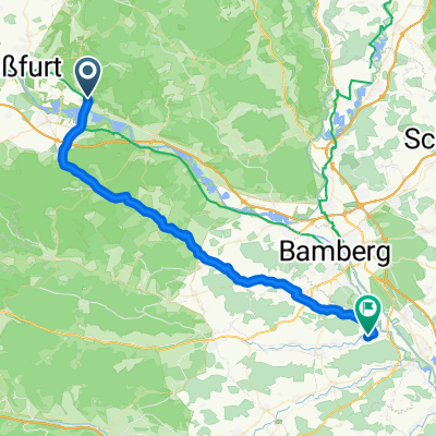
Zeil - Sand - Fatschenbrunn - Zeil
A cycling route starting in Zeil, Bavaria, Germany.
Overview
About this route
Dienstag-Abend-Tour,
Dauer: ca. 1,5 - 2 Stunden
ca. 30%Schotter und 70%Asphalt
- -:--
- Duration
- 32.9 km
- Distance
- 474 m
- Ascent
- 473 m
- Descent
- ---
- Avg. speed
- ---
- Max. altitude
Route quality
Waytypes & surfaces along the route
Waytypes
Busy road
9.8 km
(30 %)
Road
9.5 km
(29 %)
Surfaces
Paved
16.5 km
(50 %)
Unpaved
8.1 km
(25 %)
Asphalt
15.7 km
(48 %)
Gravel
6.4 km
(19 %)
Continue with Bikemap
Use, edit, or download this cycling route
You would like to ride Zeil - Sand - Fatschenbrunn - Zeil or customize it for your own trip? Here is what you can do with this Bikemap route:
Free features
- Save this route as favorite or in collections
- Copy & plan your own version of this route
- Sync your route with Garmin or Wahoo
Premium features
Free trial for 3 days, or one-time payment. More about Bikemap Premium.
- Navigate this route on iOS & Android
- Export a GPX / KML file of this route
- Create your custom printout (try it for free)
- Download this route for offline navigation
Discover more Premium features.
Get Bikemap PremiumFrom our community
Other popular routes starting in Zeil
 Zeiler Forst + Käpelle
- Distance
- 22.5 km
- Ascent
- 401 m
- Descent
- 401 m
- Location
- Zeil, Bavaria, Germany
 Rückweg Zeil am Main - Pettstadt
- Distance
- 41.3 km
- Ascent
- 175 m
- Descent
- 162 m
- Location
- Zeil, Bavaria, Germany
 Steinbrecher Weg
- Distance
- 24.6 km
- Ascent
- 407 m
- Descent
- 405 m
- Location
- Zeil, Bavaria, Germany
 "Die heiligen Länder" der Hassberge
- Distance
- 52.6 km
- Ascent
- 843 m
- Descent
- 843 m
- Location
- Zeil, Bavaria, Germany
 Zeil ObSchwappach 13 Zell 7 Obschleichach 6 Tretzendorf 5 Eltmann 7
- Distance
- 48.9 km
- Ascent
- 288 m
- Descent
- 293 m
- Location
- Zeil, Bavaria, Germany
 Main Viereth
- Distance
- 44.7 km
- Ascent
- 101 m
- Descent
- 97 m
- Location
- Zeil, Bavaria, Germany
 Zeil Königsb 10 Hofh 9 Mechenried 7 Haßfurt 11 Zeil 8
- Distance
- 46 km
- Ascent
- 236 m
- Descent
- 236 m
- Location
- Zeil, Bavaria, Germany
 Egelsbach-Zeil-Sand-Limbach-Eltmann-Egelsbach
- Distance
- 18.1 km
- Ascent
- 62 m
- Descent
- 78 m
- Location
- Zeil, Bavaria, Germany
Open it in the app