

Neighbourhood route
A cycling route starting in Dundas Valley, New South Wales, Australia.
Overview
About this route
A bike track which goes accross smooth decents as well as steep acents combined with sneaky shortcutes throughout the neighbourod.
- -:--
- Duration
- 4.6 km
- Distance
- 99 m
- Ascent
- 99 m
- Descent
- ---
- Avg. speed
- ---
- Max. altitude

Route quality
Waytypes & surfaces along the route
Waytypes
Quiet road
3.9 km
(84 %)
Road
0.6 km
(13 %)
Pedestrian area
0.1 km
(3 %)
Surfaces
Paved
4.5 km
(97 %)
Paved (undefined)
3.4 km
(73 %)
Asphalt
1.1 km
(24 %)
Undefined
0.1 km
(3 %)
Continue with Bikemap
Use, edit, or download this cycling route
You would like to ride Neighbourhood route or customize it for your own trip? Here is what you can do with this Bikemap route:
Free features
- Save this route as favorite or in collections
- Copy & plan your own version of this route
- Sync your route with Garmin or Wahoo
Premium features
Free trial for 3 days, or one-time payment. More about Bikemap Premium.
- Navigate this route on iOS & Android
- Export a GPX / KML file of this route
- Create your custom printout (try it for free)
- Download this route for offline navigation
Discover more Premium features.
Get Bikemap PremiumFrom our community
Other popular routes starting in Dundas Valley
 224 Marsden Road, Carlingford to 126–128 Fox Valley Road, Wahroonga
- Distance
- 14.1 km
- Ascent
- 210 m
- Descent
- 160 m
- Location
- Dundas Valley, New South Wales, Australia
 Dundas Valley to Meadowbank - Avoiding Traffic
- Distance
- 6.8 km
- Ascent
- 70 m
- Descent
- 138 m
- Location
- Dundas Valley, New South Wales, Australia
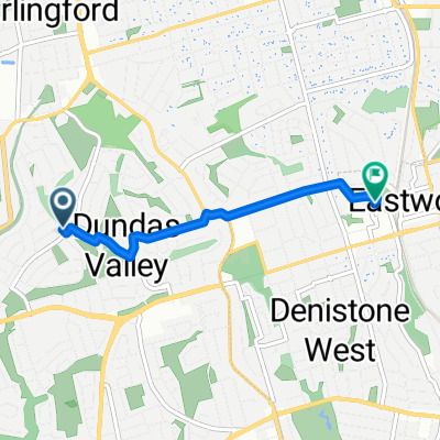 From Dundas Valley to Eastwood
- Distance
- 3.8 km
- Ascent
- 84 m
- Descent
- 72 m
- Location
- Dundas Valley, New South Wales, Australia
 Neighbourhood route
- Distance
- 4.6 km
- Ascent
- 99 m
- Descent
- 99 m
- Location
- Dundas Valley, New South Wales, Australia
 Dandarbong Avenue 37, Carlingford to Buyuma Street 10, Carlingford
- Distance
- 8.3 km
- Ascent
- 22 m
- Descent
- 37 m
- Location
- Dundas Valley, New South Wales, Australia
 14 Epping Park Drive, Epping to Waratah Street, Melrose Park
- Distance
- 33.4 km
- Ascent
- 47 m
- Descent
- 146 m
- Location
- Dundas Valley, New South Wales, Australia
 Weekday traffic route
- Distance
- 13.9 km
- Ascent
- 172 m
- Descent
- 164 m
- Location
- Dundas Valley, New South Wales, Australia
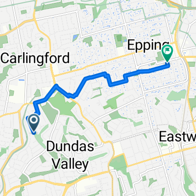 From Dundas Valley to Epping
- Distance
- 5.2 km
- Ascent
- 84 m
- Descent
- 47 m
- Location
- Dundas Valley, New South Wales, Australia
Open it in the app