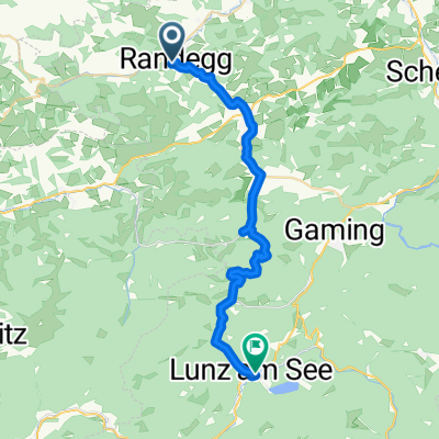
Franzenreith-Panorama-Perwarth
A cycling route starting in Randegg, Lower Austria, Austria.
Overview
About this route
- -:--
- Duration
- 32.6 km
- Distance
- 767 m
- Ascent
- 767 m
- Descent
- ---
- Avg. speed
- ---
- Avg. speed
Route quality
Waytypes & surfaces along the route
Waytypes
Quiet road
17.5 km
(54 %)
Track
5.7 km
(17 %)
Surfaces
Paved
15.8 km
(48 %)
Unpaved
3.3 km
(10 %)
Asphalt
14.2 km
(43 %)
Unpaved (undefined)
1.6 km
(5 %)
Continue with Bikemap
Use, edit, or download this cycling route
You would like to ride Franzenreith-Panorama-Perwarth or customize it for your own trip? Here is what you can do with this Bikemap route:
Free features
- Save this route as favorite or in collections
- Copy & plan your own version of this route
- Sync your route with Garmin or Wahoo
Premium features
Free trial for 3 days, or one-time payment. More about Bikemap Premium.
- Navigate this route on iOS & Android
- Export a GPX / KML file of this route
- Create your custom printout (try it for free)
- Download this route for offline navigation
Discover more Premium features.
Get Bikemap PremiumFrom our community
Other popular routes starting in Randegg
- Randegg
- Distance
- 62.3 km
- Ascent
- 605 m
- Descent
- 606 m
- Location
- Randegg, Lower Austria, Austria
- Dorffeld 1a, Perwarth nach Dorffeld 1a, Perwarth
- Distance
- 13 km
- Ascent
- 575 m
- Descent
- 598 m
- Location
- Randegg, Lower Austria, Austria
- Franzenreith-Panorama-Perwarth
- Distance
- 32.6 km
- Ascent
- 767 m
- Descent
- 767 m
- Location
- Randegg, Lower Austria, Austria
- RANDEGG HOCHKOGEL
- Distance
- 1.2 km
- Ascent
- 34 m
- Descent
- 12 m
- Location
- Randegg, Lower Austria, Austria
- Dorffeld 14, Perwarth nach Grazer Straße 26, Mariazell
- Distance
- 133.9 km
- Ascent
- 1,994 m
- Descent
- 1,495 m
- Location
- Randegg, Lower Austria, Austria
- Franzenreith Runde
- Distance
- 17.6 km
- Ascent
- 496 m
- Descent
- 496 m
- Location
- Randegg, Lower Austria, Austria
- Senioren NÖ Radwandertag nach Bad Traunstein 111
- Distance
- 74.9 km
- Ascent
- 1,599 m
- Descent
- 1,112 m
- Location
- Randegg, Lower Austria, Austria
- Mostviertler Höhenstraße nach Sonntag er und retour
- Distance
- 35.6 km
- Ascent
- 1,518 m
- Descent
- 1,518 m
- Location
- Randegg, Lower Austria, Austria
Open it in the app