
2020 Herzroute
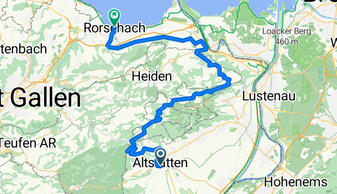
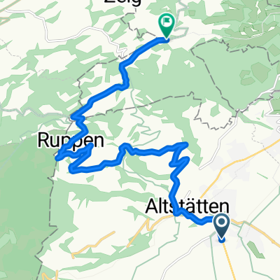
ch20-so09_Altstätten-Rorschach
A cycling route starting in Altstätten, Canton of St. Gallen, Switzerland.
Overview
About this route
- -:--
- Duration
- 37.3 km
- Distance
- 1,112 m
- Ascent
- 1,168 m
- Descent
- ---
- Avg. speed
- ---
- Max. altitude

Part of
2020 Herzroute
9 stages
Route quality
Waytypes & surfaces along the route
Waytypes
Road
25 km
(67 %)
Quiet road
8.2 km
(22 %)
Surfaces
Paved
26.1 km
(70 %)
Asphalt
26.1 km
(70 %)
Undefined
11.2 km
(30 %)
Continue with Bikemap
Use, edit, or download this cycling route
You would like to ride ch20-so09_Altstätten-Rorschach or customize it for your own trip? Here is what you can do with this Bikemap route:
Free features
- Save this route as favorite or in collections
- Copy & plan your own version of this route
- Sync your route with Garmin or Wahoo
Premium features
Free trial for 3 days, or one-time payment. More about Bikemap Premium.
- Navigate this route on iOS & Android
- Export a GPX / KML file of this route
- Create your custom printout (try it for free)
- Download this route for offline navigation
Discover more Premium features.
Get Bikemap PremiumFrom our community
Other popular routes starting in Altstätten
 Altstätten - Hölzlisberg - Brülisau
- Distance
- 18.1 km
- Ascent
- 623 m
- Descent
- 172 m
- Location
- Altstätten, Canton of St. Gallen, Switzerland
 Furkajoch
- Distance
- 117.6 km
- Ascent
- 1,877 m
- Descent
- 1,943 m
- Location
- Altstätten, Canton of St. Gallen, Switzerland
 Altstätten-ObererGäbris-Gais-Hirschberg-Altstätten
- Distance
- 36.3 km
- Ascent
- 1,197 m
- Descent
- 1,197 m
- Location
- Altstätten, Canton of St. Gallen, Switzerland
 Altstätten nach Schaan, am Rhein entlang nach Altstätten
- Distance
- 61.9 km
- Ascent
- 239 m
- Descent
- 699 m
- Location
- Altstätten, Canton of St. Gallen, Switzerland
 L'Alpe Rheintal
- Distance
- 12.4 km
- Ascent
- 759 m
- Descent
- 90 m
- Location
- Altstätten, Canton of St. Gallen, Switzerland
 RHEINDELTA - ROUTE
- Distance
- 59.2 km
- Ascent
- 93 m
- Descent
- 93 m
- Location
- Altstätten, Canton of St. Gallen, Switzerland
 1034_stanton
- Distance
- 22.3 km
- Ascent
- 983 m
- Descent
- 980 m
- Location
- Altstätten, Canton of St. Gallen, Switzerland
 Altstätten-Appenzell-Schwägalp-urnäsch- äbris- Altstätten
- Distance
- 76.3 km
- Ascent
- 1,955 m
- Descent
- 1,953 m
- Location
- Altstätten, Canton of St. Gallen, Switzerland
Open it in the app