

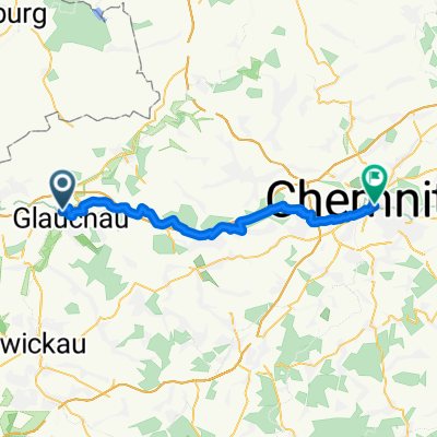
Mulderadweg - Abschnitt Glauchau bis Rochlitz (Zwickauer Mulde)
A cycling route starting in Glauchau, Saxony, Germany.
Overview
About this route
This is the fourth section on the Zwickauer Mulde with a total length of 44.7 km.
- -:--
- Duration
- 44.2 km
- Distance
- 453 m
- Ascent
- 534 m
- Descent
- ---
- Avg. speed
- ---
- Max. altitude

Route quality
Waytypes & surfaces along the route
Waytypes
Quiet road
15.9 km
(36 %)
Road
11.5 km
(26 %)
Surfaces
Paved
31.4 km
(71 %)
Unpaved
8.8 km
(20 %)
Asphalt
31.4 km
(71 %)
Gravel
4 km
(9 %)
Continue with Bikemap
Use, edit, or download this cycling route
You would like to ride Mulderadweg - Abschnitt Glauchau bis Rochlitz (Zwickauer Mulde) or customize it for your own trip? Here is what you can do with this Bikemap route:
Free features
- Save this route as favorite or in collections
- Copy & plan your own version of this route
- Sync your route with Garmin or Wahoo
Premium features
Free trial for 3 days, or one-time payment. More about Bikemap Premium.
- Navigate this route on iOS & Android
- Export a GPX / KML file of this route
- Create your custom printout (try it for free)
- Download this route for offline navigation
Discover more Premium features.
Get Bikemap PremiumFrom our community
Other popular routes starting in Glauchau
 Glauchau - Chemnitz
- Distance
- 37.2 km
- Ascent
- 442 m
- Descent
- 375 m
- Location
- Glauchau, Saxony, Germany
 RBT Glauchau - Gera
- Distance
- 46.6 km
- Ascent
- 248 m
- Descent
- 294 m
- Location
- Glauchau, Saxony, Germany
 Feierabend Runde um Glauchau
- Distance
- 32.4 km
- Ascent
- 179 m
- Descent
- 207 m
- Location
- Glauchau, Saxony, Germany
 Laubenweg nach Schwarzer Weg
- Distance
- 16.5 km
- Ascent
- 312 m
- Descent
- 309 m
- Location
- Glauchau, Saxony, Germany
 Mit Netti zum Fahren
- Distance
- 48.8 km
- Ascent
- 416 m
- Descent
- 414 m
- Location
- Glauchau, Saxony, Germany
 Mulderadweg - Abschnitt Glauchau bis Rochlitz (Zwickauer Mulde)
- Distance
- 44.2 km
- Ascent
- 453 m
- Descent
- 534 m
- Location
- Glauchau, Saxony, Germany
 2308
2308- Distance
- 30.5 km
- Ascent
- 215 m
- Descent
- 214 m
- Location
- Glauchau, Saxony, Germany
 Radtour kindgerecht ab 4 Jahre
- Distance
- 17.8 km
- Ascent
- 67 m
- Descent
- 34 m
- Location
- Glauchau, Saxony, Germany
Open it in the app