
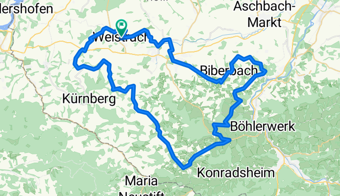
2020_Mostviertel
A cycling route starting in Weistrach, Lower Austria, Austria.
Overview
About this route
- -:--
- Duration
- 61.4 km
- Distance
- 720 m
- Ascent
- 720 m
- Descent
- ---
- Avg. speed
- ---
- Max. altitude

Route quality
Waytypes & surfaces along the route
Waytypes
Road
41.1 km
(67 %)
Quiet road
16 km
(26 %)
Surfaces
Paved
24.6 km
(40 %)
Unpaved
0.6 km
(1 %)
Asphalt
24.6 km
(40 %)
Gravel
0.6 km
(1 %)
Undefined
36.2 km
(59 %)
Continue with Bikemap
Use, edit, or download this cycling route
You would like to ride 2020_Mostviertel or customize it for your own trip? Here is what you can do with this Bikemap route:
Free features
- Save this route as favorite or in collections
- Copy & plan your own version of this route
- Sync your route with Garmin or Wahoo
Premium features
Free trial for 3 days, or one-time payment. More about Bikemap Premium.
- Navigate this route on iOS & Android
- Export a GPX / KML file of this route
- Create your custom printout (try it for free)
- Download this route for offline navigation
Discover more Premium features.
Get Bikemap PremiumFrom our community
Other popular routes starting in Weistrach
 Neuhofen/Ybbs - Rosenau
- Distance
- 56.3 km
- Ascent
- 308 m
- Descent
- 311 m
- Location
- Weistrach, Lower Austria, Austria
 2023_05_01_Mostviertel
- Distance
- 64.2 km
- Ascent
- 993 m
- Descent
- 993 m
- Location
- Weistrach, Lower Austria, Austria
 Stockerkogel
- Distance
- 8 km
- Ascent
- 241 m
- Descent
- 239 m
- Location
- Weistrach, Lower Austria, Austria
 Rohrbach 19, Weistrach nach Vestenthal 79, Vestenthal
- Distance
- 49.4 km
- Ascent
- 639 m
- Descent
- 664 m
- Location
- Weistrach, Lower Austria, Austria
 2020_Mostviertel
- Distance
- 61.4 km
- Ascent
- 720 m
- Descent
- 720 m
- Location
- Weistrach, Lower Austria, Austria
 Lahmers
- Distance
- 18.7 km
- Ascent
- 225 m
- Descent
- 243 m
- Location
- Weistrach, Lower Austria, Austria
 Weistrachrunde
- Distance
- 14.1 km
- Ascent
- 229 m
- Descent
- 230 m
- Location
- Weistrach, Lower Austria, Austria
 Ernsthofen - St. Valentin - Ennsdorf
- Distance
- 44.5 km
- Ascent
- 232 m
- Descent
- 707 m
- Location
- Weistrach, Lower Austria, Austria
Open it in the app