

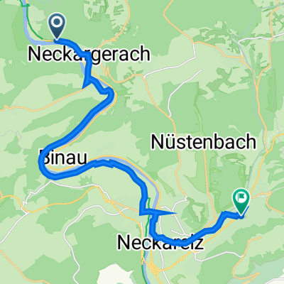
Neckargerach - Waldbrunn - Scheidental - Langenelz - Roßhof - Seckachtal - Möckmühl - Jagst - Neckarschleuse - BFH Schillerstr.
A cycling route starting in Neckargerach, Baden-Wurttemberg, Germany.
Overview
About this route
- -:--
- Duration
- 87 km
- Distance
- 496 m
- Ascent
- 483 m
- Descent
- ---
- Avg. speed
- ---
- Max. altitude

Route quality
Waytypes & surfaces along the route
Waytypes
Track
40 km
(46 %)
Quiet road
28.7 km
(33 %)
Surfaces
Paved
70.5 km
(81 %)
Unpaved
9.6 km
(11 %)
Asphalt
67 km
(77 %)
Gravel
9.6 km
(11 %)
Continue with Bikemap
Use, edit, or download this cycling route
You would like to ride Neckargerach - Waldbrunn - Scheidental - Langenelz - Roßhof - Seckachtal - Möckmühl - Jagst - Neckarschleuse - BFH Schillerstr. or customize it for your own trip? Here is what you can do with this Bikemap route:
Free features
- Save this route as favorite or in collections
- Copy & plan your own version of this route
- Split it into stages to create a multi-day tour
- Sync your route with Garmin or Wahoo
Premium features
Free trial for 3 days, or one-time payment. More about Bikemap Premium.
- Navigate this route on iOS & Android
- Export a GPX / KML file of this route
- Create your custom printout (try it for free)
- Download this route for offline navigation
Discover more Premium features.
Get Bikemap PremiumFrom our community
Other popular routes starting in Neckargerach
 Wanderbahn
- Distance
- 46 km
- Ascent
- 954 m
- Descent
- 955 m
- Location
- Neckargerach, Baden-Wurttemberg, Germany
 Neckargerach - Drei Burgen für Mountainbiker auf einen Streich
- Distance
- 20.8 km
- Ascent
- 661 m
- Descent
- 664 m
- Location
- Neckargerach, Baden-Wurttemberg, Germany
 Bergweg 2, Neckargerach nach Mörtelsteiner Straße 16, Neckargerach
- Distance
- 39.2 km
- Ascent
- 133 m
- Descent
- 175 m
- Location
- Neckargerach, Baden-Wurttemberg, Germany
 NG-Eberb.-NG
- Distance
- 31.1 km
- Ascent
- 524 m
- Descent
- 523 m
- Location
- Neckargerach, Baden-Wurttemberg, Germany
 B37, Neckargerach nach Hauptstraße 12, Mosbach
- Distance
- 18.1 km
- Ascent
- 65 m
- Descent
- 94 m
- Location
- Neckargerach, Baden-Wurttemberg, Germany
 NECKAR TOUR
- Distance
- 116.5 km
- Ascent
- 402 m
- Descent
- 296 m
- Location
- Neckargerach, Baden-Wurttemberg, Germany
 Dieter Fahrrad 1
- Distance
- 17.5 km
- Ascent
- 240 m
- Descent
- 240 m
- Location
- Neckargerach, Baden-Wurttemberg, Germany
 N'gerach - Odenwald - Seckach - Jagst
- Distance
- 88.8 km
- Ascent
- 537 m
- Descent
- 525 m
- Location
- Neckargerach, Baden-Wurttemberg, Germany
Open it in the app