
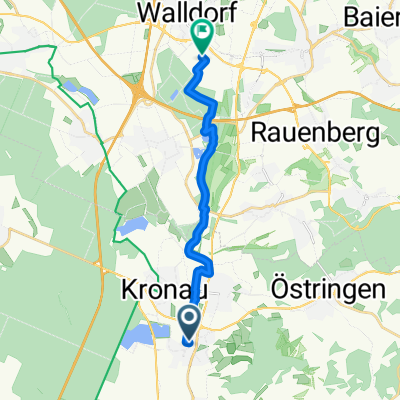
SAP Rot nach Wiesloch durch den Wald
A cycling route starting in Kronau, Baden-Wurttemberg, Germany.
Overview
About this route
The route goes through the forest over a railway bridge to Frauenweiler and then continues to Wiesloch. This section is completely flat, slightly shorter than the Gänsberg route, but tends to remain muddy for a long time in wet weather.
- -:--
- Duration
- 9 km
- Distance
- 54 m
- Ascent
- 35 m
- Descent
- ---
- Avg. speed
- ---
- Max. altitude
Route quality
Waytypes & surfaces along the route
Waytypes
Track
5 km
(56 %)
Quiet road
1.9 km
(21 %)
Surfaces
Paved
6.4 km
(71 %)
Unpaved
2.1 km
(23 %)
Asphalt
6.4 km
(71 %)
Loose gravel
1.7 km
(19 %)
Continue with Bikemap
Use, edit, or download this cycling route
You would like to ride SAP Rot nach Wiesloch durch den Wald or customize it for your own trip? Here is what you can do with this Bikemap route:
Free features
- Save this route as favorite or in collections
- Copy & plan your own version of this route
- Sync your route with Garmin or Wahoo
Premium features
Free trial for 3 days, or one-time payment. More about Bikemap Premium.
- Navigate this route on iOS & Android
- Export a GPX / KML file of this route
- Create your custom printout (try it for free)
- Download this route for offline navigation
Discover more Premium features.
Get Bikemap PremiumFrom our community
Other popular routes starting in Kronau
 In der Gänsweide, Bad Schönborn to Industriestraße, Walldorf
- Distance
- 13.1 km
- Ascent
- 24 m
- Descent
- 30 m
- Location
- Kronau, Baden-Wurttemberg, Germany
 Vorderodenwald
- Distance
- 82.6 km
- Ascent
- 1,010 m
- Descent
- 964 m
- Location
- Kronau, Baden-Wurttemberg, Germany
 Bester Weg SAP ROT - Mannheim
- Distance
- 37.5 km
- Ascent
- 59 m
- Descent
- 70 m
- Location
- Kronau, Baden-Wurttemberg, Germany
 Kleine SAP ITS Kraichgaurunde
- Distance
- 33.4 km
- Ascent
- 198 m
- Descent
- 201 m
- Location
- Kronau, Baden-Wurttemberg, Germany
 Welterbe-Tour
- Distance
- 77.8 km
- Ascent
- 512 m
- Descent
- 400 m
- Location
- Kronau, Baden-Wurttemberg, Germany
 Kraichgau-Triathlon (2. Runde)
- Distance
- 50.8 km
- Ascent
- 746 m
- Descent
- 740 m
- Location
- Kronau, Baden-Wurttemberg, Germany
 BW-Rundfahrt
- Distance
- 801 km
- Ascent
- 1,081 m
- Descent
- 1,082 m
- Location
- Kronau, Baden-Wurttemberg, Germany
 Kraichgau - BS, Sinsheim Burg
- Distance
- 47.5 km
- Ascent
- 503 m
- Descent
- 500 m
- Location
- Kronau, Baden-Wurttemberg, Germany
Open it in the app