

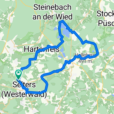
Selters-Test
A cycling route starting in Selters, Rhineland-Palatinate, Germany.
Overview
About this route
- -:--
- Duration
- 1.3 km
- Distance
- 16 m
- Ascent
- 4 m
- Descent
- ---
- Avg. speed
- ---
- Max. altitude

Route quality
Waytypes & surfaces along the route
Waytypes
Quiet road
0.4 km
(34 %)
Pedestrian area
0.2 km
(14 %)
Surfaces
Paved
0.6 km
(48 %)
Asphalt
0.6 km
(48 %)
Undefined
0.7 km
(52 %)
Route highlights
Points of interest along the route
Point of interest after 0 km
Point of interest after 0.3 km
Point of interest after 0.9 km
Continue with Bikemap
Use, edit, or download this cycling route
You would like to ride Selters-Test or customize it for your own trip? Here is what you can do with this Bikemap route:
Free features
- Save this route as favorite or in collections
- Copy & plan your own version of this route
- Sync your route with Garmin or Wahoo
Premium features
Free trial for 3 days, or one-time payment. More about Bikemap Premium.
- Navigate this route on iOS & Android
- Export a GPX / KML file of this route
- Create your custom printout (try it for free)
- Download this route for offline navigation
Discover more Premium features.
Get Bikemap PremiumFrom our community
Other popular routes starting in Selters
 Selters-Test
- Distance
- 1.3 km
- Ascent
- 16 m
- Descent
- 4 m
- Location
- Selters, Rhineland-Palatinate, Germany
 westerwald
- Distance
- 32.1 km
- Ascent
- 561 m
- Descent
- 561 m
- Location
- Selters, Rhineland-Palatinate, Germany
 Langsame Fahrt in Maxsain
- Distance
- 3.8 km
- Ascent
- 57 m
- Descent
- 22 m
- Location
- Selters, Rhineland-Palatinate, Germany
 Wiedstraße 15, Selters nach Hauptstraße 125, Bendorf
- Distance
- 26.1 km
- Ascent
- 72 m
- Descent
- 244 m
- Location
- Selters, Rhineland-Palatinate, Germany
 10.05.2019?
- Distance
- 34.9 km
- Ascent
- 444 m
- Descent
- 442 m
- Location
- Selters, Rhineland-Palatinate, Germany
 westerwald
- Distance
- 32.1 km
- Ascent
- 474 m
- Descent
- 474 m
- Location
- Selters, Rhineland-Palatinate, Germany
 Westerwald Radweg
- Distance
- 32.4 km
- Ascent
- 448 m
- Descent
- 449 m
- Location
- Selters, Rhineland-Palatinate, Germany
 Saynstraße 17, Verbandsgemeinde Selters nach Koblenz-Olper-Straße 80, Bendorf
- Distance
- 25.2 km
- Ascent
- 128 m
- Descent
- 340 m
- Location
- Selters, Rhineland-Palatinate, Germany
Open it in the app