

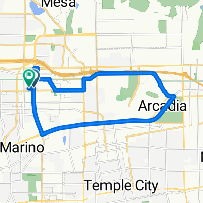
Restful route in Pasadena
A cycling route starting in East Pasadena, California, United States.
Overview
About this route
- 28 min
- Duration
- 7.7 km
- Distance
- 49 m
- Ascent
- 50 m
- Descent
- 16.2 km/h
- Avg. speed
- ---
- Max. altitude

Route quality
Waytypes & surfaces along the route
Waytypes
Road
3.4 km
(44 %)
Quiet road
3.2 km
(41 %)
Surfaces
Paved
1.4 km
(18 %)
Asphalt
1.4 km
(18 %)
Undefined
6.3 km
(82 %)
Continue with Bikemap
Use, edit, or download this cycling route
You would like to ride Restful route in Pasadena or customize it for your own trip? Here is what you can do with this Bikemap route:
Free features
- Save this route as favorite or in collections
- Copy & plan your own version of this route
- Sync your route with Garmin or Wahoo
Premium features
Free trial for 3 days, or one-time payment. More about Bikemap Premium.
- Navigate this route on iOS & Android
- Export a GPX / KML file of this route
- Create your custom printout (try it for free)
- Download this route for offline navigation
Discover more Premium features.
Get Bikemap PremiumFrom our community
Other popular routes starting in East Pasadena
 Tour of Arcadia
- Distance
- 25.8 km
- Ascent
- 335 m
- Descent
- 335 m
- Location
- East Pasadena, California, United States
 Restful route in Pasadena
- Distance
- 7.7 km
- Ascent
- 49 m
- Descent
- 50 m
- Location
- East Pasadena, California, United States
 Altadena Hill Climb
- Distance
- 16.4 km
- Ascent
- 554 m
- Descent
- 166 m
- Location
- East Pasadena, California, United States
 2905 E California Blvd, Pasadena to 2–88 N Garfield Ave, Pasadena
- Distance
- 6.5 km
- Ascent
- 87 m
- Descent
- 28 m
- Location
- East Pasadena, California, United States
 Eaton Canyon Ride
- Distance
- 12.3 km
- Ascent
- 110 m
- Descent
- 139 m
- Location
- East Pasadena, California, United States
 Chantry Flats
- Distance
- 27 km
- Ascent
- 613 m
- Descent
- 602 m
- Location
- East Pasadena, California, United States
 Santa Anita Loop
- Distance
- 15.8 km
- Ascent
- 106 m
- Descent
- 100 m
- Location
- East Pasadena, California, United States
 201–247 S Michillinda Ave, Arcadia to 101–149 S Michillinda Ave, Arcadia
- Distance
- 0.2 km
- Ascent
- 0 m
- Descent
- 0 m
- Location
- East Pasadena, California, United States
Open it in the app