

Retos BTT inicio desconfinamiento
Sube-baja Forat del Vent - para todos los públicos
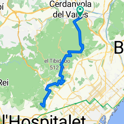
A cycling route starting in Cerdanyola del Vallès, Catalonia, Spain.
Overview
About this route
A simple challenge for all levels. The goal is to go up and down as quickly as possible without putting your feet on the ground.
- -:--
- Duration
- 10.4 km
- Distance
- 258 m
- Ascent
- 258 m
- Descent
- ---
- Avg. speed
- ---
- Max. altitude

Part of
Continue with Bikemap
Use, edit, or download this cycling route
You would like to ride Sube-baja Forat del Vent - para todos los públicos or customize it for your own trip? Here is what you can do with this Bikemap route:
Free features
- Save this route as favorite or in collections
- Copy & plan your own version of this route
- Sync your route with Garmin or Wahoo
Premium features
Free trial for 3 days, or one-time payment. More about Bikemap Premium.
- Navigate this route on iOS & Android
- Export a GPX / KML file of this route
- Create your custom printout (try it for free)
- Download this route for offline navigation
Discover more Premium features.
Get Bikemap PremiumFrom our community
Other popular routes starting in Cerdanyola del Vallès
 Ruta54 Tot per pista. Casi
- Distance
- 28.6 km
- Ascent
- 498 m
- Descent
- 505 m
- Location
- Cerdanyola del Vallès, Catalonia, Spain
 BCN-CRÑ Nov_2015
- Distance
- 1,140.7 km
- Ascent
- 3,049 m
- Descent
- 3,116 m
- Location
- Cerdanyola del Vallès, Catalonia, Spain
 Ruta02 Volta per Crta. Molins.
- Distance
- 43.6 km
- Ascent
- 687 m
- Descent
- 679 m
- Location
- Cerdanyola del Vallès, Catalonia, Spain
 Ruta14Quatre vents per Castellbisball
- Distance
- 53.3 km
- Ascent
- 505 m
- Descent
- 508 m
- Location
- Cerdanyola del Vallès, Catalonia, Spain
 Casi para el camion de la bimbo bosque perdido - bonus cerveza
- Distance
- 16.5 km
- Ascent
- 418 m
- Descent
- 418 m
- Location
- Cerdanyola del Vallès, Catalonia, Spain
 Ruta06Sant Feliu de Codines
- Distance
- 66.8 km
- Ascent
- 666 m
- Descent
- 664 m
- Location
- Cerdanyola del Vallès, Catalonia, Spain
 Cerdanyola-Forat del Vent
- Distance
- 16.2 km
- Ascent
- 315 m
- Descent
- 315 m
- Location
- Cerdanyola del Vallès, Catalonia, Spain
 Ruta51 Sant Pere Martir i tornada
- Distance
- 44.7 km
- Ascent
- 721 m
- Descent
- 726 m
- Location
- Cerdanyola del Vallès, Catalonia, Spain
Open it in the app