

ÄL Î? do ÄL Î?
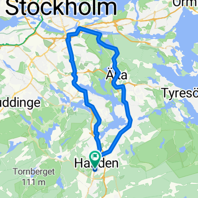
A cycling route starting in Handen, Stockholm County, Sweden.
Overview
About this route
- 45 min
- Duration
- 6.6 km
- Distance
- 72 m
- Ascent
- 72 m
- Descent
- 8.9 km/h
- Avg. speed
- ---
- Max. altitude
Route photos


Continue with Bikemap
Use, edit, or download this cycling route
You would like to ride ÄL Î? do ÄL Î? or customize it for your own trip? Here is what you can do with this Bikemap route:
Free features
- Save this route as favorite or in collections
- Copy & plan your own version of this route
- Sync your route with Garmin or Wahoo
Premium features
Free trial for 3 days, or one-time payment. More about Bikemap Premium.
- Navigate this route on iOS & Android
- Export a GPX / KML file of this route
- Create your custom printout (try it for free)
- Download this route for offline navigation
Discover more Premium features.
Get Bikemap PremiumFrom our community
Other popular routes starting in Handen
 Nynasleden
- Distance
- 91.3 km
- Ascent
- 354 m
- Descent
- 354 m
- Location
- Handen, Stockholm County, Sweden
 Rudanvägen 61 do Rudanvägen 53
- Distance
- 10.7 km
- Ascent
- 139 m
- Descent
- 143 m
- Location
- Handen, Stockholm County, Sweden
 Handen - Balta
- Distance
- 18.5 km
- Ascent
- 178 m
- Descent
- 182 m
- Location
- Handen, Stockholm County, Sweden
 ÄL Î? do ÄL Î?
- Distance
- 6.6 km
- Ascent
- 72 m
- Descent
- 72 m
- Location
- Handen, Stockholm County, Sweden
 Brief bike tour from Haninge to Jordbro
- Distance
- 3.1 km
- Ascent
- 8 m
- Descent
- 23 m
- Location
- Handen, Stockholm County, Sweden
 Hellas runt
- Distance
- 45.9 km
- Ascent
- 232 m
- Descent
- 235 m
- Location
- Handen, Stockholm County, Sweden
 handen-tyresta park-solna
- Distance
- 49 km
- Ascent
- 267 m
- Descent
- 301 m
- Location
- Handen, Stockholm County, Sweden
 Vallhornsvägen 16, Huddinge to Dalarövägen 64, Handen
- Distance
- 6.1 km
- Ascent
- 77 m
- Descent
- 60 m
- Location
- Handen, Stockholm County, Sweden
Open it in the app