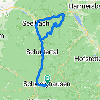
Schwarzwald Quer Schuttertal-Schramberg
A cycling route starting in Schuttertal, Baden-Württemberg, Germany.
Overview
About this route
- -:--
- Duration
- 62.5 km
- Distance
- 2,348 m
- Ascent
- 1,912 m
- Descent
- ---
- Avg. speed
- ---
- Avg. speed
Route quality
Waytypes & surfaces along the route
Waytypes
Track
27.6 km
(44 %)
Quiet road
16.2 km
(26 %)
Surfaces
Paved
22.6 km
(36 %)
Unpaved
27.9 km
(45 %)
Gravel
23.3 km
(37 %)
Asphalt
20.6 km
(33 %)
Route highlights
Points of interest along the route
Point of interest after 13.8 km
Wasser
Point of interest after 27.1 km
Wasser
Point of interest after 28.9 km
Huberfelsen - Aussicht
Point of interest after 37.3 km
Wasser
Continue with Bikemap
Use, edit, or download this cycling route
You would like to ride Schwarzwald Quer Schuttertal-Schramberg or customize it for your own trip? Here is what you can do with this Bikemap route:
Free features
- Save this route as favorite or in collections
- Copy & plan your own version of this route
- Sync your route with Garmin or Wahoo
Premium features
Free trial for 3 days, or one-time payment. More about Bikemap Premium.
- Navigate this route on iOS & Android
- Export a GPX / KML file of this route
- Create your custom printout (try it for free)
- Download this route for offline navigation
Discover more Premium features.
Get Bikemap PremiumFrom our community
Other popular routes starting in Schuttertal
- Schloßberg Herberge
- Distance
- 19.7 km
- Ascent
- 258 m
- Descent
- 480 m
- Location
- Schuttertal, Baden-Württemberg, Germany
- Waldkirch
- Distance
- 26.8 km
- Ascent
- 472 m
- Descent
- 632 m
- Location
- Schuttertal, Baden-Württemberg, Germany
- Im Wolfersbach - Schweighausen - Steinach - Biberach - Seelbach
- Distance
- 43.1 km
- Ascent
- 826 m
- Descent
- 887 m
- Location
- Schuttertal, Baden-Württemberg, Germany
- Weg zur Downhillstrecke von Welschensteinach aus
- Distance
- 0.8 km
- Ascent
- 157 m
- Descent
- 0 m
- Location
- Schuttertal, Baden-Württemberg, Germany
- Goethestraße 3, Schuttertal nach Am Schießrain 7, Schuttertal
- Distance
- 36.9 km
- Ascent
- 1,309 m
- Descent
- 1,321 m
- Location
- Schuttertal, Baden-Württemberg, Germany
- Bildsteinstraße 2A, Freiamt nach Bildsteinstraße 2A, Freiamt
- Distance
- 38.5 km
- Ascent
- 1,033 m
- Descent
- 1,017 m
- Location
- Schuttertal, Baden-Württemberg, Germany
- MTB St. Georgen Teil II
- Distance
- 69.1 km
- Ascent
- 1,171 m
- Descent
- 1,452 m
- Location
- Schuttertal, Baden-Württemberg, Germany
- Schwarzwald Quer Schuttertal-Schramberg
- Distance
- 62.5 km
- Ascent
- 2,348 m
- Descent
- 1,912 m
- Location
- Schuttertal, Baden-Württemberg, Germany
Open it in the app