
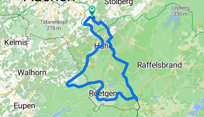
Roetgen Lammersdorf Breinig
A cycling route starting in Stolberg, North Rhine-Westphalia, Germany.
Overview
About this route
- -:--
- Duration
- 48.7 km
- Distance
- 381 m
- Ascent
- 381 m
- Descent
- ---
- Avg. speed
- ---
- Max. altitude

Route quality
Waytypes & surfaces along the route
Waytypes
Path
30.8 km
(63 %)
Quiet road
5.4 km
(11 %)
Surfaces
Paved
41.5 km
(85 %)
Unpaved
2.1 km
(4 %)
Asphalt
39.4 km
(81 %)
Gravel
2.1 km
(4 %)
Continue with Bikemap
Use, edit, or download this cycling route
You would like to ride Roetgen Lammersdorf Breinig or customize it for your own trip? Here is what you can do with this Bikemap route:
Free features
- Save this route as favorite or in collections
- Copy & plan your own version of this route
- Sync your route with Garmin or Wahoo
Premium features
Free trial for 3 days, or one-time payment. More about Bikemap Premium.
- Navigate this route on iOS & Android
- Export a GPX / KML file of this route
- Create your custom printout (try it for free)
- Download this route for offline navigation
Discover more Premium features.
Get Bikemap PremiumFrom our community
Other popular routes starting in Stolberg
 Breinig-Dreilägerbachtalsperre-Breinig
- Distance
- 21.6 km
- Ascent
- 199 m
- Descent
- 177 m
- Location
- Stolberg, North Rhine-Westphalia, Germany
 Kornelimunster to Bahnhofplatz, Aachen
- Distance
- 20 km
- Ascent
- 137 m
- Descent
- 196 m
- Location
- Stolberg, North Rhine-Westphalia, Germany
 Teil des Hasselbach Trails
- Distance
- 34.6 km
- Ascent
- 454 m
- Descent
- 418 m
- Location
- Stolberg, North Rhine-Westphalia, Germany
 Donnerberg- Diepenlinchen- Stolberger Burg
- Distance
- 8.4 km
- Ascent
- 185 m
- Descent
- 188 m
- Location
- Stolberg, North Rhine-Westphalia, Germany
 Eifelsteig all stages
- Distance
- 313 km
- Ascent
- 1,671 m
- Descent
- 1,753 m
- Location
- Stolberg, North Rhine-Westphalia, Germany
 AC-Jülich-EIfel-AC
- Distance
- 68.2 km
- Ascent
- 398 m
- Descent
- 398 m
- Location
- Stolberg, North Rhine-Westphalia, Germany
 RTF Eilendorf "Schwalbe - Tour Nordeifel"
- Distance
- 110.6 km
- Ascent
- 1,288 m
- Descent
- 1,193 m
- Location
- Stolberg, North Rhine-Westphalia, Germany
 Zwei-Talsperren-Runde
- Distance
- 45.9 km
- Ascent
- 384 m
- Descent
- 384 m
- Location
- Stolberg, North Rhine-Westphalia, Germany
Open it in the app