

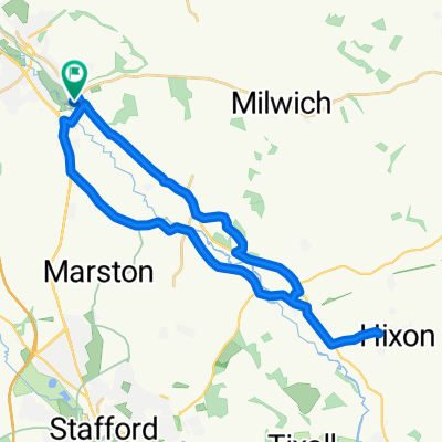
Wolsley Bridge Round
A cycling route starting in Stone, England, United Kingdom.
Overview
About this route
To the Wolsley Bridge back on Marston lane cut through via Tixall Road plus Kate's Whitehouse Lane extension
- -:--
- Duration
- 51.2 km
- Distance
- 267 m
- Ascent
- 268 m
- Descent
- ---
- Avg. speed
- ---
- Max. altitude

Route quality
Waytypes & surfaces along the route
Waytypes
Cycleway
24.6 km
(48 %)
Quiet road
11.8 km
(23 %)
Surfaces
Paved
11.8 km
(23 %)
Unpaved
0.5 km
(1 %)
Asphalt
11.8 km
(23 %)
Gravel
0.5 km
(1 %)
Undefined
38.9 km
(76 %)
Continue with Bikemap
Use, edit, or download this cycling route
You would like to ride Wolsley Bridge Round or customize it for your own trip? Here is what you can do with this Bikemap route:
Free features
- Save this route as favorite or in collections
- Copy & plan your own version of this route
- Sync your route with Garmin or Wahoo
Premium features
Free trial for 3 days, or one-time payment. More about Bikemap Premium.
- Navigate this route on iOS & Android
- Export a GPX / KML file of this route
- Create your custom printout (try it for free)
- Download this route for offline navigation
Discover more Premium features.
Get Bikemap PremiumFrom our community
Other popular routes starting in Stone
 TDTA 5
- Distance
- 106.8 km
- Ascent
- 1,055 m
- Descent
- 1,053 m
- Location
- Stone, England, United Kingdom
 trial
trial- Distance
- 27 km
- Ascent
- 90 m
- Descent
- 87 m
- Location
- Stone, England, United Kingdom
 yarnfield loop
- Distance
- 19.1 km
- Ascent
- 145 m
- Descent
- 140 m
- Location
- Stone, England, United Kingdom
 Wolsley Bridge Round
- Distance
- 51.2 km
- Ascent
- 267 m
- Descent
- 268 m
- Location
- Stone, England, United Kingdom
 stone stafford
- Distance
- 51.4 km
- Ascent
- 155 m
- Descent
- 158 m
- Location
- Stone, England, United Kingdom
 hanchurch loop
- Distance
- 36.6 km
- Ascent
- 451 m
- Descent
- 450 m
- Location
- Stone, England, United Kingdom
 Wednesday ride with Rob
- Distance
- 61.3 km
- Ascent
- 633 m
- Descent
- 633 m
- Location
- Stone, England, United Kingdom
 3 Bods 100 Miler
- Distance
- 170.8 km
- Ascent
- 495 m
- Descent
- 495 m
- Location
- Stone, England, United Kingdom
Open it in the app