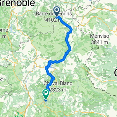
Anello Lauteret-Galibier-Alpe d'Huez
A cycling route starting in Le Mon锚tier-les-Bains, Provence-Alpes-C么te d'Azur Region, France.
Overview
About this route
- -:--
- Duration
- 168.3 km
- Distance
- 4,031 m
- Ascent
- 4,031 m
- Descent
- ---
- Avg. speed
- ---
- Avg. speed
Route quality
Waytypes & surfaces along the route
Waytypes
Busy road
104 km
(62 %)
Road
26.1 km
(16 %)
Surfaces
Paved
91.4 km
(54 %)
Unpaved
11.4 km
(7 %)
Asphalt
91 km
(54 %)
Ground
10.6 km
(6 %)
Continue with Bikemap
Use, edit, or download this cycling route
You would like to ride Anello Lauteret-Galibier-Alpe d'Huez or customize it for your own trip? Here is what you can do with this Bikemap route:
Free features
- Save this route as favorite or in collections
- Copy & plan your own version of this route
- Sync your route with Garmin or Wahoo
Premium features
Free trial for 3 days, or one-time payment. More about Bikemap Premium.
- Navigate this route on iOS & Android
- Export a GPX / KML file of this route
- Create your custom printout (try it for free)
- Download this route for offline navigation
Discover more Premium features.
Get Bikemap PremiumFrom our community
Other popular routes starting in Le Mon锚tier-les-Bains
- 27-6: Col du Galibier
- Distance
- 52.9 km
- Ascent
- 1,791 m
- Descent
- 1,781 m
- Location
- Le Mon锚tier-les-Bains, Provence-Alpes-C么te d'Azur Region, France
- Monastier Galibier Rochilles Nevache Brian莽on
- Distance
- 87.4 km
- Ascent
- 1,772 m
- Descent
- 1,809 m
- Location
- Le Mon锚tier-les-Bains, Provence-Alpes-C么te d'Azur Region, France
- Lago Verde Bardonecchia
- Distance
- 2.6 km
- Ascent
- 154 m
- Descent
- 36 m
- Location
- Le Mon锚tier-les-Bains, Provence-Alpes-C么te d'Azur Region, France
- RdGA - 'rustdag' Col du Lautaret - L'Alpe d'Huez - Col du Lautaret
- Distance
- 100.7 km
- Ascent
- 2,371 m
- Descent
- 2,371 m
- Location
- Le Mon锚tier-les-Bains, Provence-Alpes-C么te d'Azur Region, France
- Lago Thures
- Distance
- 4.4 km
- Ascent
- 587 m
- Descent
- 33 m
- Location
- Le Mon锚tier-les-Bains, Provence-Alpes-C么te d'Azur Region, France
- Le Col du Galibier, depuis le Lautaret
- Distance
- 8.7 km
- Ascent
- 592 m
- Descent
- 5 m
- Location
- Le Mon锚tier-les-Bains, Provence-Alpes-C么te d'Azur Region, France
- Anello Lauteret-Galibier-Alpe d'Huez
- Distance
- 168.3 km
- Ascent
- 4,031 m
- Descent
- 4,031 m
- Location
- Le Mon锚tier-les-Bains, Provence-Alpes-C么te d'Azur Region, France
- 2. Tag Col de Galibier
- Distance
- 21.4 km
- Ascent
- 730 m
- Descent
- 725 m
- Location
- Le Mon锚tier-les-Bains, Provence-Alpes-C么te d'Azur Region, France