Ravensburg - Obereisenbach - Ettenkirchen - Runde
A cycling route starting in Ravensburg, Baden-Wurttemberg, Germany.
Overview
About this route
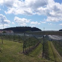
Beautiful circular route starting in Ravensburg South. From there, it goes through Weingartshof, Oberhofen, Obereschach, Gornhofen to Obereisenbach. Then continue westwards via Siggenweiler. Noteworthy is the viewpoint before Liebenau with a view of Lake Constance (photo). Continue past Spieleland through Meckenbeuren, where there are countless places to stop, e.g. directly on Bahnhofstraße. The final stage to Ettenkirchen and then back south to Ravensburg.
- -:--
- Duration
- 40.6 km
- Distance
- 470 m
- Ascent
- 476 m
- Descent
- ---
- Avg. speed
- ---
- Max. altitude
Route photos
Route quality
Waytypes & surfaces along the route
Waytypes
Road
14.2 km
(35 %)
Path
11.8 km
(29 %)
Surfaces
Paved
39.8 km
(98 %)
Asphalt
39.8 km
(98 %)
Undefined
0.8 km
(2 %)
Continue with Bikemap
Use, edit, or download this cycling route
You would like to ride Ravensburg - Obereisenbach - Ettenkirchen - Runde or customize it for your own trip? Here is what you can do with this Bikemap route:
Free features
- Save this route as favorite or in collections
- Copy & plan your own version of this route
- Sync your route with Garmin or Wahoo
Premium features
Free trial for 3 days, or one-time payment. More about Bikemap Premium.
- Navigate this route on iOS & Android
- Export a GPX / KML file of this route
- Create your custom printout (try it for free)
- Download this route for offline navigation
Discover more Premium features.
Get Bikemap PremiumFrom our community
Other popular routes starting in Ravensburg
Ravensburg - Waldburg - Runde- Distance
- 31 km
- Ascent
- 514 m
- Descent
- 517 m
- Location
- Ravensburg, Baden-Wurttemberg, Germany
Ravensburg - Hoechsten - Fleischwangen - Runde- Distance
- 54.1 km
- Ascent
- 695 m
- Descent
- 694 m
- Location
- Ravensburg, Baden-Wurttemberg, Germany
RV_GehrenbergTurm_RV- Distance
- 62.8 km
- Ascent
- 462 m
- Descent
- 464 m
- Location
- Ravensburg, Baden-Wurttemberg, Germany
Hochbergstraße nach Hochbergstraße 53/1- Distance
- 29.1 km
- Ascent
- 178 m
- Descent
- 178 m
- Location
- Ravensburg, Baden-Wurttemberg, Germany
Ravensburg bis Isny- Distance
- 48.9 km
- Ascent
- 892 m
- Descent
- 640 m
- Location
- Ravensburg, Baden-Wurttemberg, Germany
RV_Kressbronn_Selmnau_Tettnang_RV- Distance
- 54.7 km
- Ascent
- 366 m
- Descent
- 366 m
- Location
- Ravensburg, Baden-Wurttemberg, Germany
Ravensburg - Schmalegg - Berg - Runde- Distance
- 26.6 km
- Ascent
- 422 m
- Descent
- 419 m
- Location
- Ravensburg, Baden-Wurttemberg, Germany
RV_Kreuzweiher_Laimnau_RV- Distance
- 45.4 km
- Ascent
- 286 m
- Descent
- 283 m
- Location
- Ravensburg, Baden-Wurttemberg, Germany
Open it in the app


