

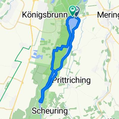
Haunstetten-egling-mering
A cycling route starting in Königsbrunn, Bavaria, Germany.
Overview
About this route
- -:--
- Duration
- 47.1 km
- Distance
- 130 m
- Ascent
- 126 m
- Descent
- ---
- Avg. speed
- 569 m
- Max. altitude

Route quality
Waytypes & surfaces along the route
Waytypes
Track
17.9 km
(38 %)
Quiet road
9.9 km
(21 %)
Surfaces
Paved
33 km
(70 %)
Unpaved
13.7 km
(29 %)
Asphalt
33 km
(70 %)
Gravel
7.5 km
(16 %)
Continue with Bikemap
Use, edit, or download this cycling route
You would like to ride Haunstetten-egling-mering or customize it for your own trip? Here is what you can do with this Bikemap route:
Free features
- Save this route as favorite or in collections
- Copy & plan your own version of this route
- Sync your route with Garmin or Wahoo
Premium features
Free trial for 3 days, or one-time payment. More about Bikemap Premium.
- Navigate this route on iOS & Android
- Export a GPX / KML file of this route
- Create your custom printout (try it for free)
- Download this route for offline navigation
Discover more Premium features.
Get Bikemap PremiumFrom our community
Other popular routes starting in Königsbrunn
 Haunstetten-prittriching-kuhsee
- Distance
- 40.1 km
- Ascent
- 47 m
- Descent
- 52 m
- Location
- Königsbrunn, Bavaria, Germany
 Inningen-Oberschönenfeld
- Distance
- 61.9 km
- Ascent
- 450 m
- Descent
- 449 m
- Location
- Königsbrunn, Bavaria, Germany
 Wörthseerunde
- Distance
- 106.3 km
- Ascent
- 637 m
- Descent
- 626 m
- Location
- Königsbrunn, Bavaria, Germany
 VIA CLAUDIA
- Distance
- 440.7 km
- Ascent
- 1,578 m
- Descent
- 1,885 m
- Location
- Königsbrunn, Bavaria, Germany
 Lochbach
- Distance
- 2.1 km
- Ascent
- 0 m
- Descent
- 10 m
- Location
- Königsbrunn, Bavaria, Germany
 Augsburg-Ammersee-Kuhsee
- Distance
- 114.2 km
- Ascent
- 484 m
- Descent
- 488 m
- Location
- Königsbrunn, Bavaria, Germany
 Route zu Wassersportcenter Mandichosee
- Distance
- 24.8 km
- Ascent
- 37 m
- Descent
- 34 m
- Location
- Königsbrunn, Bavaria, Germany
 Haunstetten-Staustufe 22_2
- Distance
- 24.1 km
- Ascent
- 57 m
- Descent
- 55 m
- Location
- Königsbrunn, Bavaria, Germany
Open it in the app