

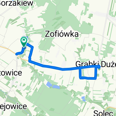
Łatwa trasa w Staszów
A cycling route starting in Gmina Gnojno, Świętokrzyskie Voivodship, Poland.
Overview
About this route
- 1 h 56 min
- Duration
- 24.5 km
- Distance
- 236 m
- Ascent
- 238 m
- Descent
- 12.7 km/h
- Avg. speed
- ---
- Max. altitude

Route quality
Waytypes & surfaces along the route
Waytypes
Quiet road
6.1 km
(25 %)
Road
4.4 km
(18 %)
Surfaces
Paved
16.7 km
(68 %)
Unpaved
0.7 km
(3 %)
Asphalt
16.7 km
(68 %)
Ground
0.7 km
(3 %)
Undefined
7.1 km
(29 %)
Continue with Bikemap
Use, edit, or download this cycling route
You would like to ride Łatwa trasa w Staszów or customize it for your own trip? Here is what you can do with this Bikemap route:
Free features
- Save this route as favorite or in collections
- Copy & plan your own version of this route
- Sync your route with Garmin or Wahoo
Premium features
Free trial for 3 days, or one-time payment. More about Bikemap Premium.
- Navigate this route on iOS & Android
- Export a GPX / KML file of this route
- Create your custom printout (try it for free)
- Download this route for offline navigation
Discover more Premium features.
Get Bikemap PremiumFrom our community
Other popular routes starting in Gmina Gnojno
 Skadla do Grabki Małe
- Distance
- 28.5 km
- Ascent
- 210 m
- Descent
- 258 m
- Location
- Gmina Gnojno, Świętokrzyskie Voivodship, Poland
 Janowice Poduszowskie 56, Gnojno do Gnojno 157, Gnojno
- Distance
- 5.3 km
- Ascent
- 160 m
- Descent
- 118 m
- Location
- Gmina Gnojno, Świętokrzyskie Voivodship, Poland
 ¿O?fi? do ¿O?fi?
- Distance
- 14.4 km
- Ascent
- 111 m
- Descent
- 58 m
- Location
- Gmina Gnojno, Świętokrzyskie Voivodship, Poland
 ÄåWfi? do ÄåWfi?
- Distance
- 37.8 km
- Ascent
- 300 m
- Descent
- 302 m
- Location
- Gmina Gnojno, Świętokrzyskie Voivodship, Poland
 Krzyżtopór
- Distance
- 95.3 km
- Ascent
- 416 m
- Descent
- 414 m
- Location
- Gmina Gnojno, Świętokrzyskie Voivodship, Poland
 1 jazda
- Distance
- 18.7 km
- Ascent
- 180 m
- Descent
- 223 m
- Location
- Gmina Gnojno, Świętokrzyskie Voivodship, Poland
 Łatwa trasa w Raczyce
- Distance
- 56.1 km
- Ascent
- 543 m
- Descent
- 545 m
- Location
- Gmina Gnojno, Świętokrzyskie Voivodship, Poland
 Łatwa trasa w Staszów
- Distance
- 24.5 km
- Ascent
- 236 m
- Descent
- 238 m
- Location
- Gmina Gnojno, Świętokrzyskie Voivodship, Poland
Open it in the app