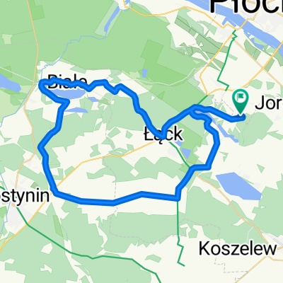
Spokojna trasa w Płock
A cycling route starting in Łąck, Masovian Voivodeship, Poland.
Overview
About this route
- 1 h 5 min
- Duration
- 11.8 km
- Distance
- 72 m
- Ascent
- 132 m
- Descent
- 10.8 km/h
- Avg. speed
- ---
- Max. altitude
Route quality
Waytypes & surfaces along the route
Waytypes
Track
5.7 km
(48 %)
Quiet road
3.3 km
(28 %)
Surfaces
Paved
7.9 km
(67 %)
Unpaved
1.4 km
(12 %)
Paved (undefined)
5 km
(42 %)
Asphalt
3 km
(25 %)
Continue with Bikemap
Use, edit, or download this cycling route
You would like to ride Spokojna trasa w Płock or customize it for your own trip? Here is what you can do with this Bikemap route:
Free features
- Save this route as favorite or in collections
- Copy & plan your own version of this route
- Sync your route with Garmin or Wahoo
Premium features
Free trial for 3 days, or one-time payment. More about Bikemap Premium.
- Navigate this route on iOS & Android
- Export a GPX / KML file of this route
- Create your custom printout (try it for free)
- Download this route for offline navigation
Discover more Premium features.
Get Bikemap PremiumFrom our community
Other popular routes starting in Łąck
- Friedensradfahrt 2009 Paris - Moskau 25. Etappe Lack - Izabelin am 1. August 2009
- Distance
- 112.6 km
- Ascent
- 120 m
- Descent
- 108 m
- Location
- Łąck, Masovian Voivodeship, Poland
- Białe 35a, Lucień do Zamkowa 31, Gostynin
- Distance
- 14.4 km
- Ascent
- 74 m
- Descent
- 103 m
- Location
- Łąck, Masovian Voivodeship, Poland
- Od Janka do Zygmunta
- Distance
- 166.9 km
- Ascent
- 217 m
- Descent
- 208 m
- Location
- Łąck, Masovian Voivodeship, Poland
- Umiarkowana trasa w Łąck
- Distance
- 29.8 km
- Ascent
- 302 m
- Descent
- 289 m
- Location
- Łąck, Masovian Voivodeship, Poland
- XC 01
- Distance
- 1 km
- Ascent
- 28 m
- Descent
- 23 m
- Location
- Łąck, Masovian Voivodeship, Poland
- XC dookoła jezior
- Distance
- 5.4 km
- Ascent
- 74 m
- Descent
- 72 m
- Location
- Łąck, Masovian Voivodeship, Poland
- Spokojna trasa w Płock
- Distance
- 11.8 km
- Ascent
- 72 m
- Descent
- 132 m
- Location
- Łąck, Masovian Voivodeship, Poland
- Gostyńsko-Włocławski Park Krajobrazowy
- Distance
- 78.4 km
- Ascent
- 419 m
- Descent
- 408 m
- Location
- Łąck, Masovian Voivodeship, Poland
Open it in the app