

?$—Î? nach ?$—Î?
A cycling route starting in Leinefelde-Worbis, Thuringia, Germany.
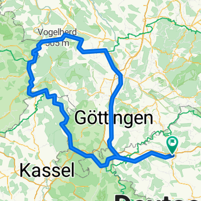
Overview
About this route
- 32 min
- Duration
- 10.1 km
- Distance
- 89 m
- Ascent
- 86 m
- Descent
- 19.1 km/h
- Avg. speed
- ---
- Max. altitude
Route quality
Waytypes & surfaces along the route
Waytypes
Path
3.2 km
(31 %)
Access road
2.9 km
(29 %)
Surfaces
Paved
7.4 km
(74 %)
Unpaved
0.8 km
(8 %)
Asphalt
6.6 km
(66 %)
Gravel
0.8 km
(8 %)
Continue with Bikemap
Use, edit, or download this cycling route
You would like to ride ?$—Î? nach ?$—Î? or customize it for your own trip? Here is what you can do with this Bikemap route:
Free features
- Save this route as favorite or in collections
- Copy & plan your own version of this route
- Sync your route with Garmin or Wahoo
Premium features
Free trial for 3 days, or one-time payment. More about Bikemap Premium.
- Navigate this route on iOS & Android
- Export a GPX / KML file of this route
- Create your custom printout (try it for free)
- Download this route for offline navigation
Discover more Premium features.
Get Bikemap PremiumFrom our community
Other popular routes starting in Leinefelde-Worbis
 (Mini-) Leinerunde 2: Beuren - Scharfenstein - Beuren
- Distance
- 17.3 km
- Ascent
- 264 m
- Descent
- 264 m
- Location
- Leinefelde-Worbis, Thuringia, Germany
 Leine - Weser - Leinefelde Sep. 2025
- Distance
- 279.9 km
- Ascent
- 1,669 m
- Descent
- 1,665 m
- Location
- Leinefelde-Worbis, Thuringia, Germany
 Tagebau
- Distance
- 18.6 km
- Ascent
- 339 m
- Descent
- 203 m
- Location
- Leinefelde-Worbis, Thuringia, Germany
 Leine Heide Radweg - Leinefelde-Hamburg
- Distance
- 402.5 km
- Ascent
- 274 m
- Descent
- 593 m
- Location
- Leinefelde-Worbis, Thuringia, Germany
 Leine-Heide-Radweg Original
- Distance
- 403.3 km
- Ascent
- 275 m
- Descent
- 596 m
- Location
- Leinefelde-Worbis, Thuringia, Germany
 Burg Bodenstein
- Distance
- 35.8 km
- Ascent
- 471 m
- Descent
- 473 m
- Location
- Leinefelde-Worbis, Thuringia, Germany
 Lfld.-Arensh.-Etzelbach
- Distance
- 70.8 km
- Ascent
- 517 m
- Descent
- 517 m
- Location
- Leinefelde-Worbis, Thuringia, Germany
 Tagebau
- Distance
- 37.4 km
- Ascent
- 410 m
- Descent
- 412 m
- Location
- Leinefelde-Worbis, Thuringia, Germany
Open it in the app