

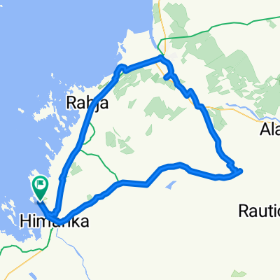
Virpiranta-Rautila-Pöntiö-Himangan-kk-Virpiranta
A cycling route starting in Himanka, North Ostrobothnia, Finland.
Overview
About this route
Sora- ja asvalttitietä, sopii myös hybridipyörälle.
- -:--
- Duration
- 25.1 km
- Distance
- 45 m
- Ascent
- 40 m
- Descent
- ---
- Avg. speed
- ---
- Max. altitude

Route quality
Waytypes & surfaces along the route
Waytypes
Road
9.8 km
(39 %)
Quiet road
9 km
(36 %)
Surfaces
Paved
14 km
(56 %)
Unpaved
4 km
(16 %)
Asphalt
9.5 km
(38 %)
Paved (undefined)
4.5 km
(18 %)
Continue with Bikemap
Use, edit, or download this cycling route
You would like to ride Virpiranta-Rautila-Pöntiö-Himangan-kk-Virpiranta or customize it for your own trip? Here is what you can do with this Bikemap route:
Free features
- Save this route as favorite or in collections
- Copy & plan your own version of this route
- Sync your route with Garmin or Wahoo
Premium features
Free trial for 3 days, or one-time payment. More about Bikemap Premium.
- Navigate this route on iOS & Android
- Export a GPX / KML file of this route
- Create your custom printout (try it for free)
- Download this route for offline navigation
Discover more Premium features.
Get Bikemap PremiumFrom our community
Other popular routes starting in Himanka
 Bit of biking on a Monday morning or afternoon
- Distance
- 85.3 km
- Ascent
- 85 m
- Descent
- 86 m
- Location
- Himanka, North Ostrobothnia, Finland
 Virpiranta-Rautila-Pöntiö-Himangan-kk-Virpiranta
- Distance
- 25.1 km
- Ascent
- 45 m
- Descent
- 40 m
- Location
- Himanka, North Ostrobothnia, Finland
 himanka
- Distance
- 72.5 km
- Ascent
- 112 m
- Descent
- 113 m
- Location
- Himanka, North Ostrobothnia, Finland
 Virpiranta-Ohtakari
- Distance
- 23.6 km
- Ascent
- 38 m
- Descent
- 35 m
- Location
- Himanka, North Ostrobothnia, Finland
 Virpiranta/Himanka-Kannus-Ullava-Ullavanjärvi-Toholampi-Kannus-Virpiranta/Himanka
- Distance
- 146.8 km
- Ascent
- 0 m
- Descent
- 0 m
- Location
- Himanka, North Ostrobothnia, Finland
 Himanka-Kannus-Ullava-Rahkonen-Viitasalo-Toholampi-Jämsä-Kannus-Himanka
- Distance
- 149.9 km
- Ascent
- 165 m
- Descent
- 167 m
- Location
- Himanka, North Ostrobothnia, Finland
 Virpiranta/Himanka-Typpö-Tynkä-Hiekkasärkät-Virpiranta/Himanka
- Distance
- 84.4 km
- Ascent
- 79 m
- Descent
- 77 m
- Location
- Himanka, North Ostrobothnia, Finland
 Himanka-Tokola-Kannus-Rautio-Typpö-Pahkala-Pöntiö-Himanka
- Distance
- 102.9 km
- Ascent
- 114 m
- Descent
- 112 m
- Location
- Himanka, North Ostrobothnia, Finland
Open it in the app