

Grömitz 04
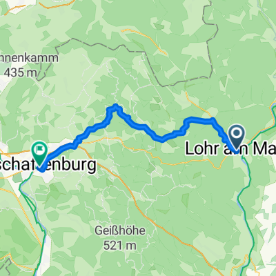
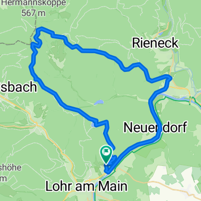
A cycling route starting in Lohr a. Main, Bavaria, Germany.
Overview
About this route
- -:--
- Duration
- 95.5 km
- Distance
- 286 m
- Ascent
- 203 m
- Descent
- ---
- Avg. speed
- ---
- Max. altitude

Route quality
Waytypes & surfaces along the route
Waytypes
Track
38.2 km
(40 %)
Quiet road
19.1 km
(20 %)
Surfaces
Paved
72.6 km
(76 %)
Unpaved
18.1 km
(19 %)
Asphalt
68.8 km
(72 %)
Gravel
12.4 km
(13 %)
Route highlights
Points of interest along the route
Point of interest after 95.5 km
Unterkunft 9 Tagesetappe 74 km 1325
Accommodation after 95.5 km
Unterkunft 8 Tagesetappe 80 km 1250
Continue with Bikemap
Use, edit, or download this cycling route
You would like to ride Grömitz 04 or customize it for your own trip? Here is what you can do with this Bikemap route:
Free features
- Save this route as favorite or in collections
- Copy & plan your own version of this route
- Split it into stages to create a multi-day tour
- Sync your route with Garmin or Wahoo
Premium features
Free trial for 3 days, or one-time payment. More about Bikemap Premium.
- Navigate this route on iOS & Android
- Export a GPX / KML file of this route
- Create your custom printout (try it for free)
- Download this route for offline navigation
Discover more Premium features.
Get Bikemap PremiumFrom our community
Other popular routes starting in Lohr a. Main
 Lohr am Main - Beckstein
- Distance
- 86.2 km
- Ascent
- 264 m
- Descent
- 146 m
- Location
- Lohr a. Main, Bavaria, Germany
 Ausfahrt durch Lohr am Main
- Distance
- 27.1 km
- Ascent
- 364 m
- Descent
- 367 m
- Location
- Lohr a. Main, Bavaria, Germany
 Kupfermühle(Lohr)-Partenstein-HLohrTal
- Distance
- 51.2 km
- Ascent
- 477 m
- Descent
- 491 m
- Location
- Lohr a. Main, Bavaria, Germany
 Lohr am Main - Aschaffenburg
- Distance
- 46.1 km
- Ascent
- 849 m
- Descent
- 880 m
- Location
- Lohr a. Main, Bavaria, Germany
 Lohr - Kreuzberg
- Distance
- 83.6 km
- Ascent
- 1,518 m
- Descent
- 865 m
- Location
- Lohr a. Main, Bavaria, Germany
 The Fog
- Distance
- 41 km
- Ascent
- 683 m
- Descent
- 683 m
- Location
- Lohr a. Main, Bavaria, Germany
 1ter Tag alternative
- Distance
- 41.6 km
- Ascent
- 531 m
- Descent
- 480 m
- Location
- Lohr a. Main, Bavaria, Germany
 Mainradweg Lohr - Bürgstadt
- Distance
- 76.4 km
- Ascent
- 670 m
- Descent
- 699 m
- Location
- Lohr a. Main, Bavaria, Germany
Open it in the app