

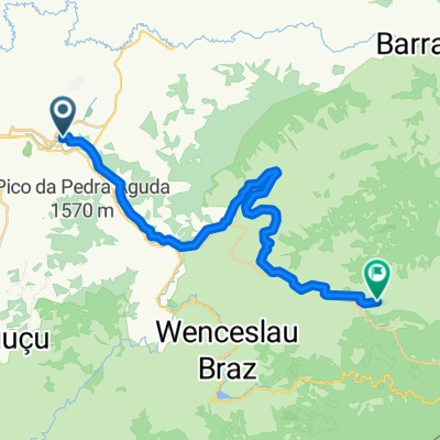
Rota repousante em Itajubá
A cycling route starting in Itajubá, Minas Gerais, Brazil.
Overview
About this route
- 24 min
- Duration
- 5.7 km
- Distance
- 100 m
- Ascent
- 16 m
- Descent
- 14.2 km/h
- Avg. speed
- ---
- Max. altitude
Route quality
Waytypes & surfaces along the route
Waytypes
Busy road
3.1 km
(54 %)
Quiet road
1.3 km
(24 %)
Surfaces
Paved
1.9 km
(34 %)
Unpaved
0.2 km
(3 %)
Paved (undefined)
1.6 km
(27 %)
Asphalt
0.3 km
(5 %)
Continue with Bikemap
Use, edit, or download this cycling route
You would like to ride Rota repousante em Itajubá or customize it for your own trip? Here is what you can do with this Bikemap route:
Free features
- Save this route as favorite or in collections
- Copy & plan your own version of this route
- Sync your route with Garmin or Wahoo
Premium features
Free trial for 3 days, or one-time payment. More about Bikemap Premium.
- Navigate this route on iOS & Android
- Export a GPX / KML file of this route
- Create your custom printout (try it for free)
- Download this route for offline navigation
Discover more Premium features.
Get Bikemap PremiumFrom our community
Other popular routes starting in Itajubá
 SÃO JOÃO
- Distance
- 25.8 km
- Ascent
- 1,012 m
- Descent
- 1,007 m
- Location
- Itajubá, Minas Gerais, Brazil
 Cachoeira do Túnel
- Distance
- 26.7 km
- Ascent
- 384 m
- Descent
- 123 m
- Location
- Itajubá, Minas Gerais, Brazil
 Itajubá - Delfim Moreira
- Distance
- 35.7 km
- Ascent
- 500 m
- Descent
- 132 m
- Location
- Itajubá, Minas Gerais, Brazil
 Passeio rápido em Brasopolis MG 😊😍🙏
- Distance
- 4.8 km
- Ascent
- 100 m
- Descent
- 172 m
- Location
- Itajubá, Minas Gerais, Brazil
 Itajubá - Bananal
- Distance
- 353.9 km
- Ascent
- 3,396 m
- Descent
- 3,790 m
- Location
- Itajubá, Minas Gerais, Brazil
 Cachoeira da Estância
- Distance
- 25 km
- Ascent
- 454 m
- Descent
- 452 m
- Location
- Itajubá, Minas Gerais, Brazil
 Itajubá - Piranguinho
- Distance
- 12.4 km
- Ascent
- 301 m
- Descent
- 309 m
- Location
- Itajubá, Minas Gerais, Brazil
 Trilha do Defunto
- Distance
- 51.5 km
- Ascent
- 858 m
- Descent
- 861 m
- Location
- Itajubá, Minas Gerais, Brazil
Open it in the app