

ÄL#?? nach ÄL#??
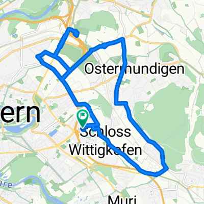
A cycling route starting in Ostermundigen, Canton of Bern, Switzerland.
Overview
About this route
- 58 min
- Duration
- 16.7 km
- Distance
- 111 m
- Ascent
- 111 m
- Descent
- 17.4 km/h
- Avg. speed
- ---
- Max. altitude

Route quality
Waytypes & surfaces along the route
Waytypes
Quiet road
7.9 km
(47 %)
Track
1.5 km
(9 %)
Surfaces
Paved
11.5 km
(69 %)
Unpaved
2.5 km
(15 %)
Asphalt
11.5 km
(69 %)
Gravel
1.8 km
(11 %)
Continue with Bikemap
Use, edit, or download this cycling route
You would like to ride ÄL#?? nach ÄL#?? or customize it for your own trip? Here is what you can do with this Bikemap route:
Free features
- Save this route as favorite or in collections
- Copy & plan your own version of this route
- Sync your route with Garmin or Wahoo
Premium features
Free trial for 3 days, or one-time payment. More about Bikemap Premium.
- Navigate this route on iOS & Android
- Export a GPX / KML file of this route
- Create your custom printout (try it for free)
- Download this route for offline navigation
Discover more Premium features.
Get Bikemap PremiumFrom our community
Other popular routes starting in Ostermundigen
 Recovered Route
- Distance
- 37.9 km
- Ascent
- 915 m
- Descent
- 911 m
- Location
- Ostermundigen, Canton of Bern, Switzerland
 Aaretal - Gürbetal PS
- Distance
- 56.7 km
- Ascent
- 148 m
- Descent
- 196 m
- Location
- Ostermundigen, Canton of Bern, Switzerland
 Entspannende Route in Ostermundigen
- Distance
- 22.9 km
- Ascent
- 604 m
- Descent
- 602 m
- Location
- Ostermundigen, Canton of Bern, Switzerland
 Velotour 2020_1
- Distance
- 305.3 km
- Ascent
- 700 m
- Descent
- 684 m
- Location
- Ostermundigen, Canton of Bern, Switzerland
 Wohlensee
- Distance
- 57.2 km
- Ascent
- 431 m
- Descent
- 429 m
- Location
- Ostermundigen, Canton of Bern, Switzerland
 Krauchthal
- Distance
- 18.1 km
- Ascent
- 620 m
- Descent
- 632 m
- Location
- Ostermundigen, Canton of Bern, Switzerland
 Bern Rundfahrt
- Distance
- 33.8 km
- Ascent
- 472 m
- Descent
- 487 m
- Location
- Ostermundigen, Canton of Bern, Switzerland
 Late afternoon
- Distance
- 15.2 km
- Ascent
- 61 m
- Descent
- 60 m
- Location
- Ostermundigen, Canton of Bern, Switzerland
Open it in the app