

Basislager Trier (Kylltal-Tour)
A cycling route starting in Metterich, Rhineland-Palatinate, Germany.
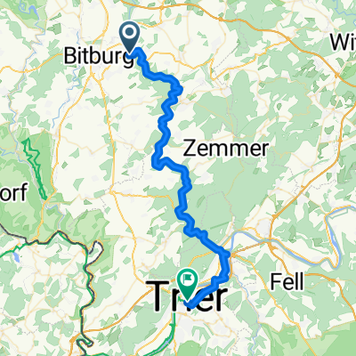
Overview
About this route
Follow the Kyll River through the hilly landscape of the southern Eifel with its unique natural scenery all the way to its confluence with the Moselle.
- -:--
- Duration
- 49.2 km
- Distance
- 190 m
- Ascent
- 289 m
- Descent
- ---
- Avg. speed
- ---
- Max. altitude

Route quality
Waytypes & surfaces along the route
Waytypes
Path
23.1 km
(47 %)
Track
10.3 km
(21 %)
Surfaces
Paved
44.7 km
(91 %)
Unpaved
3.4 km
(7 %)
Asphalt
42.8 km
(87 %)
Gravel
3.4 km
(7 %)
Continue with Bikemap
Use, edit, or download this cycling route
You would like to ride Basislager Trier (Kylltal-Tour) or customize it for your own trip? Here is what you can do with this Bikemap route:
Free features
- Save this route as favorite or in collections
- Copy & plan your own version of this route
- Sync your route with Garmin or Wahoo
Premium features
Free trial for 3 days, or one-time payment. More about Bikemap Premium.
- Navigate this route on iOS & Android
- Export a GPX / KML file of this route
- Create your custom printout (try it for free)
- Download this route for offline navigation
Discover more Premium features.
Get Bikemap PremiumFrom our community
Other popular routes starting in Metterich
 EDorf_BIT_IRREL_WBillig_Trier
- Distance
- 68.9 km
- Ascent
- 220 m
- Descent
- 324 m
- Location
- Metterich, Rhineland-Palatinate, Germany
 ruhig. Rotue.Flugplatz.masholder .Rotue
- Distance
- 14.2 km
- Ascent
- 119 m
- Descent
- 169 m
- Location
- Metterich, Rhineland-Palatinate, Germany
 erdorf oberweis abseits
- Distance
- 17.9 km
- Ascent
- 266 m
- Descent
- 273 m
- Location
- Metterich, Rhineland-Palatinate, Germany
 Erdorf-Bitburg-Minden-Heim
- Distance
- 65.1 km
- Ascent
- 353 m
- Descent
- 404 m
- Location
- Metterich, Rhineland-Palatinate, Germany
 Metterich - Trier
- Distance
- 43.9 km
- Ascent
- 22 m
- Descent
- 103 m
- Location
- Metterich, Rhineland-Palatinate, Germany
 Tag 5 Bitborg-Erdorf - Mertesdorf
- Distance
- 47.9 km
- Ascent
- 410 m
- Descent
- 489 m
- Location
- Metterich, Rhineland-Palatinate, Germany
 Vulkaneifel
- Distance
- 62.2 km
- Ascent
- 948 m
- Descent
- 815 m
- Location
- Metterich, Rhineland-Palatinate, Germany
 MoselXL E3 Bitburg-Trier
- Distance
- 49.4 km
- Ascent
- 156 m
- Descent
- 257 m
- Location
- Metterich, Rhineland-Palatinate, Germany
Open it in the app