

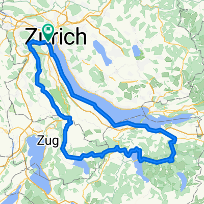
Sihlcity - Albis - Thürlersee - Uitikon - Goldbrunnenplatz
A cycling route starting in Zürich (Kreis 3) / Alt-Wiedikon, Canton of Zurich, Switzerland.
Overview
About this route
- -:--
- Duration
- 31.7 km
- Distance
- 466 m
- Ascent
- 461 m
- Descent
- ---
- Avg. speed
- ---
- Max. altitude

Route quality
Waytypes & surfaces along the route
Waytypes
Path
3.8 km
(12 %)
Quiet road
1 km
(3 %)
Surfaces
Paved
31.4 km
(99 %)
Asphalt
31.4 km
(99 %)
Undefined
0.3 km
(1 %)
Continue with Bikemap
Use, edit, or download this cycling route
You would like to ride Sihlcity - Albis - Thürlersee - Uitikon - Goldbrunnenplatz or customize it for your own trip? Here is what you can do with this Bikemap route:
Free features
- Save this route as favorite or in collections
- Copy & plan your own version of this route
- Sync your route with Garmin or Wahoo
Premium features
Free trial for 3 days, or one-time payment. More about Bikemap Premium.
- Navigate this route on iOS & Android
- Export a GPX / KML file of this route
- Create your custom printout (try it for free)
- Download this route for offline navigation
Discover more Premium features.
Get Bikemap PremiumFrom our community
Other popular routes starting in Zürich (Kreis 3) / Alt-Wiedikon
 Ueteliberg Tour
- Distance
- 16.5 km
- Ascent
- 475 m
- Descent
- 489 m
- Location
- Zürich (Kreis 3) / Alt-Wiedikon, Canton of Zurich, Switzerland
 Wiedikon - Zugersee Runde
- Distance
- 98.2 km
- Ascent
- 959 m
- Descent
- 870 m
- Location
- Zürich (Kreis 3) / Alt-Wiedikon, Canton of Zurich, Switzerland
 Wolframplatz (Vision Apts) to Adliswil (Sood-Oberleimbach)
- Distance
- 5.6 km
- Ascent
- 24 m
- Descent
- 0 m
- Location
- Zürich (Kreis 3) / Alt-Wiedikon, Canton of Zurich, Switzerland
 Sihlcity - Albis - Thürlersee - Uitikon - Goldbrunnenplatz
- Distance
- 31.7 km
- Ascent
- 466 m
- Descent
- 461 m
- Location
- Zürich (Kreis 3) / Alt-Wiedikon, Canton of Zurich, Switzerland
 Zürich - Buchenegg - Mühliberg - Hedingen - Landikon - Zürich
- Distance
- 35.7 km
- Ascent
- 608 m
- Descent
- 603 m
- Location
- Zürich (Kreis 3) / Alt-Wiedikon, Canton of Zurich, Switzerland
 Schlosstour Aargau
- Distance
- 123.2 km
- Ascent
- 1,374 m
- Descent
- 1,374 m
- Location
- Zürich (Kreis 3) / Alt-Wiedikon, Canton of Zurich, Switzerland
 Zürich-Sattelegg-Raten-Türlersee-Zürich
- Distance
- 122.9 km
- Ascent
- 1,958 m
- Descent
- 1,870 m
- Location
- Zürich (Kreis 3) / Alt-Wiedikon, Canton of Zurich, Switzerland
 Zürich-Matraia (Etappe 1)
- Distance
- 164.5 km
- Ascent
- 2,404 m
- Descent
- 1,753 m
- Location
- Zürich (Kreis 3) / Alt-Wiedikon, Canton of Zurich, Switzerland
Open it in the app