Vercors
A cycling route starting in Saint-Jean-en-Royans, Auvergne-Rh么ne-Alpes, France.
Overview
About this route
From Vassieux-en-Vercors: Road of La Come Laval
Valley of the Choranche
In Rencurel: Road of the Ecouges up to St-Gervais
- -:--
- Duration
- 71.5 km
- Distance
- 1,383 m
- Ascent
- 2,183 m
- Descent
- ---
- Avg. speed
- ---
- Max. altitude
Route quality
Waytypes & surfaces along the route
Waytypes
Road
17.9 km
(25 %)
Quiet road
5.7 km
(8 %)
Surfaces
Paved
59.3 km
(83 %)
Unpaved
0.7 km
(1 %)
Asphalt
59.3 km
(83 %)
Ground
0.7 km
(1 %)
Undefined
11.4 km
(16 %)
Continue with Bikemap
Use, edit, or download this cycling route
You would like to ride Vercors or customize it for your own trip? Here is what you can do with this Bikemap route:
Free features
- Save this route as favorite or in collections
- Copy & plan your own version of this route
- Sync your route with Garmin or Wahoo
Premium features
Free trial for 3 days, or one-time payment. More about Bikemap Premium.
- Navigate this route on iOS & Android
- Export a GPX / KML file of this route
- Create your custom printout (try it for free)
- Download this route for offline navigation
Discover more Premium features.
Get Bikemap PremiumFrom our community
Other popular routes starting in Saint-Jean-en-Royans
- Combe Lavel Rundtour 50km
- Distance
- 41.5 km
- Ascent
- 1,613 m
- Descent
- 1,600 m
- Location
- Saint-Jean-en-Royans, Auvergne-Rh么ne-Alpes, France
- testers bliss
- Distance
- 27.6 km
- Ascent
- 294 m
- Descent
- 294 m
- Location
- Saint-Jean-en-Royans, Auvergne-Rh么ne-Alpes, France
- Avenue du Sert 2, Saint-Jean-en-Royans nach Avenue du Sert 4, Saint-Jean-en-Royans
- Distance
- 63.3 km
- Ascent
- 1,498 m
- Descent
- 1,496 m
- Location
- Saint-Jean-en-Royans, Auvergne-Rh么ne-Alpes, France
- Vercors 4
- Distance
- 120.8 km
- Ascent
- 2,221 m
- Descent
- 2,221 m
- Location
- Saint-Jean-en-Royans, Auvergne-Rh么ne-Alpes, France
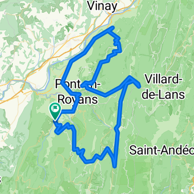
- Avenue du Sert 2, Saint-Jean-en-Royans nach Avenue du Sert 2, Saint-Jean-en-Royans
- Distance
- 77.4 km
- Ascent
- 2,019 m
- Descent
- 2,018 m
- Location
- Saint-Jean-en-Royans, Auvergne-Rh么ne-Alpes, France
- Parcours Vercors Saint Jean en Royans
- Distance
- 138 km
- Ascent
- 2,952 m
- Descent
- 2,955 m
- Location
- Saint-Jean-en-Royans, Auvergne-Rh么ne-Alpes, France
- Combe Lavel Rundtour 50km
- Distance
- 37.8 km
- Ascent
- 1,821 m
- Descent
- 1,807 m
- Location
- Saint-Jean-en-Royans, Auvergne-Rh么ne-Alpes, France
- Col de Rousset Plus 10 More Vercors Cols from Bataille
- Distance
- 128.2 km
- Ascent
- 2,159 m
- Descent
- 2,169 m
- Location
- Saint-Jean-en-Royans, Auvergne-Rh么ne-Alpes, France
Open it in the app