

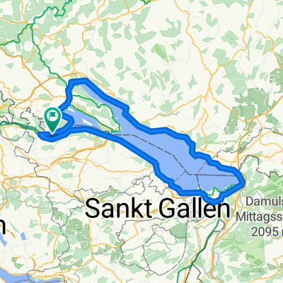
Öhningen-Klingenzell-Mammern und zurück
A cycling route starting in Öhningen, Baden-Wurttemberg, Germany.
Overview
About this route
Gently downhill from Öhningen to Stein (CH), then across the Rhine toward the station. On the cycle path along the railway line towards Eschenz. In Eschenz, fairly steep climb (5%) on the road, after a few hundred meters turn left into a small wooded area towards Klingenzell. Uphill (6 - 8%, short ramps up to 13%) to the chapel (+ inn). On the left is a lovely bench with a great view. Then a bit more uphill, then downhill, so far all paved roads, partly very lightly trafficked. In a wooded area, a fairly wide forest path appears on the left, not marked on any map. It leads to Mammern, not difficult to ride. In Mammern just past the railway, back onto the cycle path and return to Öhningen.
- -:--
- Duration
- 18.6 km
- Distance
- 303 m
- Ascent
- 303 m
- Descent
- ---
- Avg. speed
- ---
- Max. altitude
Continue with Bikemap
Use, edit, or download this cycling route
You would like to ride Öhningen-Klingenzell-Mammern und zurück or customize it for your own trip? Here is what you can do with this Bikemap route:
Free features
- Save this route as favorite or in collections
- Copy & plan your own version of this route
- Sync your route with Garmin or Wahoo
Premium features
Free trial for 3 days, or one-time payment. More about Bikemap Premium.
- Navigate this route on iOS & Android
- Export a GPX / KML file of this route
- Create your custom printout (try it for free)
- Download this route for offline navigation
Discover more Premium features.
Get Bikemap PremiumFrom our community
Other popular routes starting in Öhningen
 Bodensee Umrundung
- Distance
- 197.3 km
- Ascent
- 765 m
- Descent
- 791 m
- Location
- Öhningen, Baden-Wurttemberg, Germany
 Öhningen-Konstanz über Seerücken und zurück am See
- Distance
- 60.3 km
- Ascent
- 412 m
- Descent
- 412 m
- Location
- Öhningen, Baden-Wurttemberg, Germany
 Öhningen Ramsen Buch Hemishofen Öhningen
- Distance
- 32.4 km
- Ascent
- 349 m
- Descent
- 349 m
- Location
- Öhningen, Baden-Wurttemberg, Germany
 Stein am Rhein-Padova
- Distance
- 579.3 km
- Ascent
- 3,668 m
- Descent
- 4,076 m
- Location
- Öhningen, Baden-Wurttemberg, Germany
 Bodensee Rund um den Untersee
- Distance
- 72.3 km
- Ascent
- 128 m
- Descent
- 130 m
- Location
- Öhningen, Baden-Wurttemberg, Germany
 Eine Runde auf und um den Schienerberg m. Mar.
- Distance
- 27.9 km
- Ascent
- 407 m
- Descent
- 407 m
- Location
- Öhningen, Baden-Wurttemberg, Germany
 Zum Rheinfall
- Distance
- 29.2 km
- Ascent
- 193 m
- Descent
- 216 m
- Location
- Öhningen, Baden-Wurttemberg, Germany
 MTB Tour Schiener Berg
- Distance
- 27.1 km
- Ascent
- 780 m
- Descent
- 777 m
- Location
- Öhningen, Baden-Wurttemberg, Germany
Open it in the app